4 Management of marine biodiversity
Safeguarding marine biodiversity must be an integral part of ocean management. In addition to being crucial for the marine environment itself, an ocean management regime that can maintain and enhance biodiversity and biological production is important for maintaining and strengthening ecosystem services that are vital to people, and for improving the resilience of the oceans to the impacts of climate change. The extent of intact ecosystems can be boosted through integrated ocean management, including coordination and sound spatial management of marine areas. Natural ecosystem functions and services have a decisive role to play in addressing the problems associated with biodiversity loss and climate change. This is something the Norwegian Government recognises as an important consideration in developing an integrated ocean management system. With this white paper, the Government is continuing to develop its efforts to ensure the conservation of areas of special importance for marine biodiversity as part of an integrated, sustainable and ecosystem-based ocean management regime. The sustainable use of ocean areas for commercial activities is discussed in Chapters 5 and 7.
Norway considers it important to ensure knowledge-based, integrated and responsible management of marine and coastal waters. Mapping, research and environmental monitoring provide a sound knowledge base for the management system. By building up knowledge, we gain a better understanding of marine ecosystems and their functions, including the provision of ecosystem services that benefit people. The knowledge base will also provide a better basis for developing a system of ocean accounts, which is discussed later in this chapter. This system will include the development of ecosystem accounting for the oceans, which includes the valuation of marine ecosystems and ecosystem services. An overall scientific review of the particularly valuable and vulnerable areas has been completed since the previous white paper on the management plans was published, thus improving the basis for one important element of the integrated ocean management system.
4.1 Particularly valuable and vulnerable areas
Particularly valuable and vulnerable areas are identified on the basis of scientific assessments as being of great importance for biodiversity and biological production in an entire management plan area. This system is both a scientific way of identifying areas of particular value and an important basis for knowledge-based management of marine areas. The designation of areas as particularly valuable and vulnerable does not have any direct effect in the form of restrictions on commercial activities, but indicates that these are areas where it is important to show special caution, and where activities must be conducted in such a way that the ecological functioning and biodiversity of an area is not threatened.
The occurrence and geographical distribution of valuable ecological features is used as a starting point for delimiting particularly valuable and vulnerable areas. After this, the vulnerability of each area is assessed separately. The areas are selected using predefined criteria, the main ones being their importance for biodiversity or for biological production. To describe the overall environmental value of each area, it needs to be assessed against the criteria for EBSAs (ecologically or biologically significant marine areas), which is an internationally recognised scientific method for identifying valuable marine areas, developed under the UN Convention on Biological Diversity. Such areas are often to be found where there are distinctive topographic or oceanographic features. Areas may for example be identified as particularly valuable and vulnerable because they are important habitats or spawning grounds for fish, important habitats for seabirds and marine mammals, or contain coral reefs.
4.1.1 Particularly valuable and vulnerable areas and implications for economic activity
The identification of particularly valuable and vulnerable areas is not in itself an administrative measure. These areas do not have any special legal status and their designation does not have other direct effects in the form of conservation measures or restrictions on or a framework for economic activity. However, the designation of areas does indicate a need for special caution, for example to safeguard biodiversity and biological production. The authorities can evaluate whether there is a need to introduce a framework for activities in specific areas.
The identification of an area as particularly valuable and vulnerable does not automatically determine which management measures are relevant or whether a framework for economic activity should be introduced, and if so for which types of activities. Any political decision on a framework for activities in a specific area will be based on an assessment of the level of environmental pressure and risk that is considered to be acceptable, weighed against the benefits to society of permitting economic activity. The area or areas to which a framework for a particular activity applies will not necessarily coincide with the boundaries of particularly valuable and vulnerable areas. This will be further assessed based on the best available scientific information about the spatial and temporal distribution of valuable ecological features and when and where they are vulnerable to different types of activity. We need to find the most appropriate ways of incorporating concerns about the ecological value of individual areas, but without making the framework for economic activity in fields such as petroleum, CCS, offshore wind, seabed minerals, fisheries, aquaculture and shipping more restrictive than needed to safeguard the valuable ecological features of each area.
The pressures that human activities may put on the valuable ecological features of an area, and their possible impacts, must be assessed to identify relevant management measures. It is important to recognise that ecological features may exhibit varying degrees of vulnerability to different pressures, and that the distribution of many ecological features varies over space and time.
A cautious approach can be built into integrated ocean management by setting an overall framework that protects valuable ecological features against pressures to which they are vulnerable. Different sectors can exercise due care through spatial planning for commercial activities. The authorities can make it clear that businesses are expected or required to exercise due care when planning and carrying out their activities. The competent authorities must evaluate whether businesses are in fact exercising due care, or whether it is necessary to establish separate requirements for specific activities. To ensure proper assessments relating to due care, it is also essential to ensure the involvement of the authorities for relevant sectors and dialogue between them and the environmental authorities.
There is already extensive commercial activity in Norwegian ocean areas, including the particularly valuable and vulnerable areas that have been identified. For example, several oil and gas fields and many of the most important and intensively used fishing grounds are within particularly valuable and vulnerable areas. A number of management measures have already been implemented, some of which apply to specific geographical areas while others are more general. These measures influence the extent to which particular activities have pressures and impacts on important ecological features. Both the pressures and impacts associated with existing activities and the effects of already existing management measures are included when assessing the need for new measures in a particularly valuable and vulnerable area.
Particularly valuable and vulnerable areas were initially identified in the white paper on the first management plan for the Barents Sea–Lofoten area (Report No. 8 (2005–2006) to the Storting). The white paper described seven areas that had been scientifically identified as particularly valuable and vulnerable. In subsequent white papers, eleven areas were identified as particularly valuable and vulnerable in the Norwegian Sea (Report No. 37 (2008–2009) to the Storting), and twelve areas in the North Sea and Skagerrak (Meld. St. 37 (2012–2013)).
An important topic in the previous white paper on the ocean management plans (Meld. St. 20 (2019–2020)) was the delimitation of the marginal ice zone as a particularly valuable and vulnerable area and the framework for petroleum activities in this area. The white paper also stated that a review of valuable species and habitats and their vulnerability in all the particularly valuable and vulnerable areas identified in the management plan areas was to be completed. Candidate areas that had been identified and if relevant, new areas, were also to be evaluated. This process was also to include an assessment of whether areas containing underwater mountains meet the criteria for designation as particularly valuable and vulnerable areas. The review was subsequently commissioned by the Forum for Integrated Ocean Management. On the basis of updated scientific evidence, interdisciplinary expert groups have presented an extensive synthesis of knowledge about valuable ecological features, intrinsic vulnerability and cumulative environmental effects in the particularly valuable and vulnerable areas.
The review of the particularly valuable and vulnerable areas is discussed below, followed by a presentation of the new set of areas and their boundaries. The approach used by the Forum for Integrated Ocean Management was to start by delimiting areas on the basis of their environmental value, and subsequently to assess vulnerability for each of the areas identified.
4.1.2 The review of particularly valuable and vulnerable areas
An interdisciplinary expert group was commissioned by the Forum for Integrated Ocean Management to propose a set of particularly valuable and vulnerable areas, based on a scientific assessment of their ecological and biological value. The expert group based its work on the existing particularly valuable and vulnerable areas, earlier valuations and new knowledge, and assessed value on the basis of the seven EBSA criteria (see Table 4.1) for identifying ecologically or biologically significant marine areas.
Seven ecosystem components were assessed using this set of criteria: sea ice biota (organisms that live in, on or associated with sea ice), plankton (phyto- and zooplankton), fish, mesopelagic fauna (animals living in the mesopelagic zone, 200–1000 m below the surface), benthic communities, marine mammals and seabirds.
Table 4.1 The EBSA criteria and their definitions
|
Criterion |
Definition |
|---|---|
|
Uniqueness or rarity |
Area contains either (i) unique (“the only one of its kind”), rare (occurs only in few locations) or endemic species, populations or communities, and/or (ii) unique, rare or distinct, habitats or ecosystems; and/or (iii) unique or unusual geomorphological or oceanographic features. |
|
Special importance for life-history stages of species |
Areas that are required for a population to survive and thrive. |
|
Importance for threatened, endangered or declining species and/or habitats |
Area containing habitat for the survival and recovery of endangered, threatened, declining species or area with significant assemblages of such species. |
|
Vulnerability, fragility, sensitivity, or slow recovery |
Areas that contain a relatively high proportion of sensitive habitats, biotopes or species that are functionally fragile (highly susceptible to degradation or depletion by human activity or by natural events) or with slow recovery. |
|
Biological productivity |
Area containing species, populations or communities with comparatively higher natural biological productivity. |
|
Biological diversity |
Area contains comparatively higher diversity of ecosystems, habitats, communities, or species, or has higher genetic diversity. |
|
Naturalness |
Area with a comparatively higher degree of naturalness as a result of the lack of or low level of human-induced disturbance or degradation. |
Source: Convention on Biological Diversity/https://www.cbd.int/decision/cop/default.shtml?id=11663
After reviewing the existing list of particularly valuable and vulnerable areas, the expert group identified a total of 19 particularly valuable and vulnerable areas in Norwegian waters. Seven of these are in the Barents Sea–Lofoten management plan area, eight in the Norwegian Sea and four in the North Sea–Skagerrak area. The geographical delimitation of all of these areas is based on the distribution of important ecological features.
Another expert group subsequently assessed the intrinsic vulnerability of a range of ecosystem components to various environmental pressures in all the particularly valuable and vulnerable areas that were identified. A thorough account of the assessment is provided in the scientific basis for this white paper. The vulnerability assessments are more systematic and science-based than previously, and in all 17 different pressures were assessed for 21 ecosystem components and sub-components. In line with the practice established by the Forum for Integrated Ocean Management, the term vulnerability was in this context understood to mean an intrinsic property of ecosystem components, and not dependent on whether or not specific environmental pressures are actually acting on them. The assessment took account of when and where different ecosystem components are present and of any particularly vulnerable life-history stages, including spawn and fry. It did not include an evaluation of whether the ecosystem components assessed are exposed to environmental pressures in the particularly valuable and vulnerable areas, or whether specific activities in these areas pose a risk to them. In some geographical areas, vulnerability varies through the year with seasonal variations in the distribution and occurrence of ecosystem components. Seabirds are for example most vulnerable at times of year when they aggregate in large numbers, for example along the coast in the breeding season (April–August) and during their swimming migration to nursery areas in the open sea (early autumn).
The ecosystem components included in the researchers’ analyses were restricted to those about which enough is known to determine whether the EBSA criteria are met. The knowledge base has been assessed as sufficient to identify the particularly valuable and vulnerable areas identified as ecologically or biologically significant. The particularly valuable and vulnerable areas are described in more detail below, in line with the scientific basis for this white paper.
4.1.3 Particularly valuable and vulnerable areas in the Barents Sea–Lofoten management plan area
On the basis of the scientific review of the particularly valuable and vulnerable areas, changes have been made to the list for the Barents Sea–Lofoten management plan area. BH1, Waters around Svalbard has been expanded to include the polar tidal front, which is no longer treated as a separate area. Four other particularly valuable and vulnerable areas have also been expanded (and three of them renamed): the Marginal Ice Zone (BH2), the Coastal Zone Finnmark (BH4), the Senja-Tromsøflaket Bank Area (BH5) and the Coastal Zone Lofoten (BH6). The Central Barents Sea (BH7) has been identified as a new particularly valuable and vulnerable area. Finally, the delimitation of Eggakanten North (BH3) is unchanged.
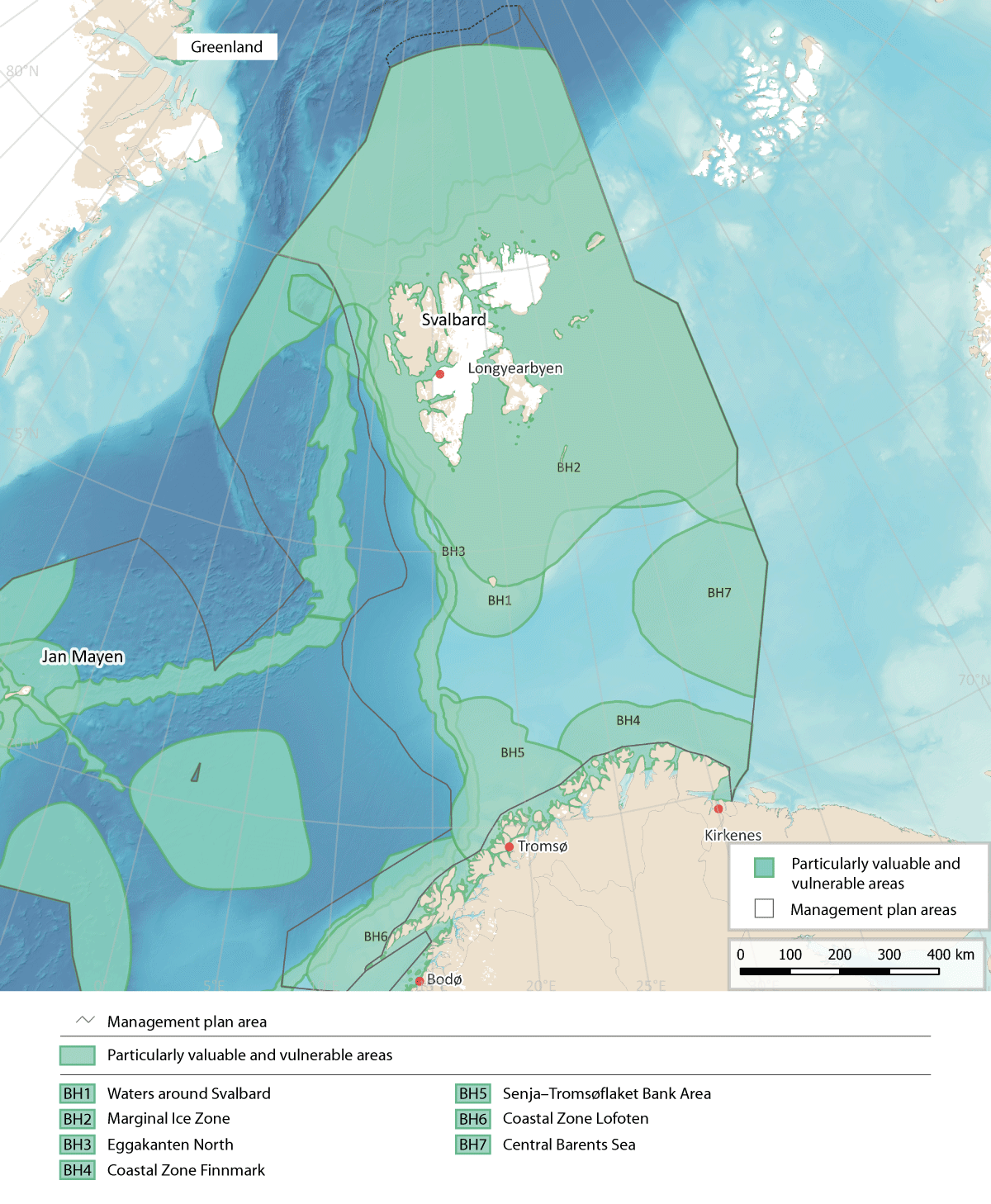
Figure 4.1 Particularly valuable and vulnerable areas in the Barents Sea-Lofoten management plan area. Note that some of the areas overlap
Source: Forum for Integrated Ocean Management/Institute of Marine Research/Norwegian Mapping Authority/ GEBCO Compilation Group (2023)
Waters around Svalbard (BH1)
This area surrounds many islands of all sizes and includes areas of open sea and also coastal waters and fjords. The topography of the seabed, current conditions and hydrography are all complex and variable. Parts of the area, including some of the fjords, may be covered by sea ice for parts of the year. Ice conditions vary from year to year.
Various species and other ecological features found in this area have a local or seasonal distribution, and some are unique to the area. Most animal life and a good proportion of the plant life of Svalbard is directly or indirectly dependent on nutrients from the sea.
Both sea ice and fjord ice in this area support ice biota. The ice biota is very distinctive, including a variety of community types and species belonging to a wide range of different groups, and therefore intrinsically valuable. It also plays a vital role in biological production, which is subsequently channelled through the food web.
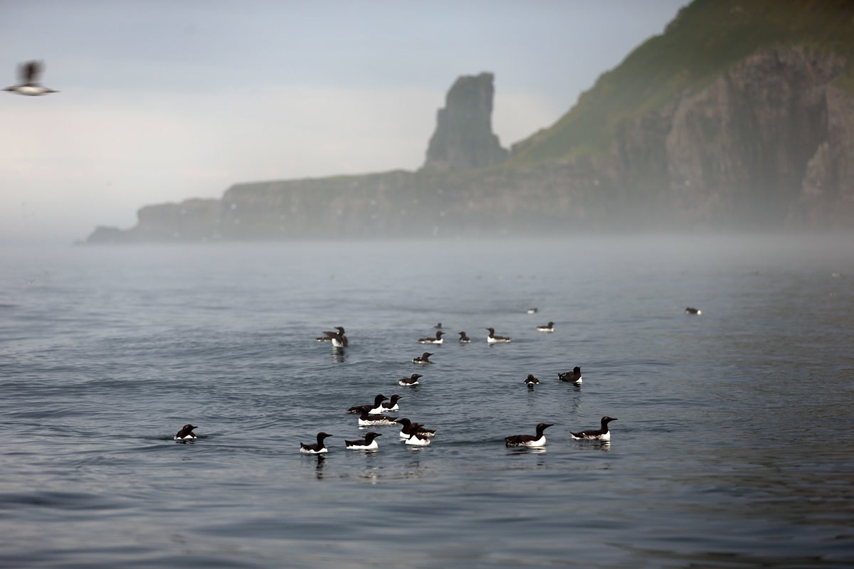
Figure 4.2 Common and Brunnich's guillemots on the sea near Bjørnøya.
Photo: Hallvard Strøm, Norwegian Polar Institute
There are important areas for phyto- and zooplankton production in the Waters around Svalbard. The Spitsbergen Bank, the Hinlopen Strait, and the underside of the fjord ice near certain glacier terminuses are examples of areas that sustain an elevated level of primary production in the water column. Glacier terminuses in the sea around the whole of the Svalbard archipelago are also important feeding areas because they support high primary production.
The Waters around Svalbard include important spawning grounds for polar cod (Boreogadus saida), nursery areas for polar cod, redfish and cod, and feeding grounds for capelin (a key species in the ecosystem), and for polar cod, cod and haddock.
In addition, this area is important for marine mammals, and is one of the parts of the Arctic where the species richness of marine mammals is highest. All the Arctic marine mammals found in the North-East Atlantic occur here, and in addition several species migrate to the area to feed in summer.
Several million seabirds breed in Svalbard, particularly in the southern and western parts of the archipelago. It is estimated that about 45 % of the Svalbard population of Brünnich’s guillemot, a threatened species, breeds around the Storfjorden (between Spitsbergen and Edgeøya).
On the Yermak Plateau northwest of Spitsbergen, there are unique, undisturbed benthic communities that are vulnerable to physical damage. There are also rich, diverse benthic communities in areas north and northeast of Svalbard. Unattached calcareous algae on the seabed (rhodoliths) have an important ecological function on the continental shelf around Svalbard.
There are substantial shrimp populations near the coast and in fjords and inlets.
The area is important for a number of threatened species, including golden redfish (endangered), various species of auks, ivory gull (vulnerable), bowhead whale (endangered), walrus (endangered), sponge aggregations (on the OSPAR List of Threatened and/or Declining Species and Habitats since 2010) and seapens. There are also several habitat types in the area that are on Norway’s red list.
The Spitsbergen Bank is a very distinctive part of the Waters around Svalbard. The level of annual primary production here may be higher than almost anywhere else in the Barents Sea. This is of crucial importance for other parts of the ecosystem as well.
There are large protected areas in and around Svalbard, and this together with other features such as ice cover and the remoteness of the area from the mainland results in limited pressure from human activities in relatively large parts of the Waters around Svalbard.
In this area, the vulnerability of zooplankton, benthic fauna, ice biota, early life stages of fish, seabirds, and Arctic ice-associated marine mammals to various pressures is assessed as high.
The benthic fauna shows high vulnerability to bycatches, abrasion and habitat loss through sealing of the substrate. Early life stages of fish show high vulnerability to pollution and the extraction of non-living resources. Seabirds and marine mammals show high vulnerability to bycatches, disturbance due to human presence, litter and pollution, including oil pollution.

Figure 4.3 Benthic fauna on the Spitsbergen Bank
Photo: Mareano/Institute of Marine Research
In addition, the zooplankton, benthic fauna, ice biota, seabirds, Arctic ice-associated marine mammals and polar bears show high vulnerability to climate change. Climate change is expected to have both positive and negative impacts on different species or life stages in most species groups, with the exception that the impacts on polar bears will be exclusively negative.
The Marginal Ice Zone (BH2)
This is a relatively large area, defined in terms of winter and summer sea ice extent in the Barents Sea. In scientific terms, the marginal ice zone is the transitional zone between open sea and ice-covered sea, where the ice concentration (the proportion of the sea surface that is ice-covered) is between 15 and 80 %. The marginal ice zone is extremely dynamic, moving annually between Bjørnøya in the south and somewhere north of Spitsbergen depending on the time of year, and with most ice to the east of Svalbard. The area delimited as the Marginal Ice Zone (BH6) is intended to cover the variable extent of the marginal ice zone, i.e. the area across which it moves during an annual cycle between maximum ice cover in April and a minimum in September. The maximum southerly extent of the marginal ice zone is largely determined by the location of the polar front, while ice melt in the summer depends on factors including air temperature, the temperature of the underlying seawater, the amount of snow on the sea ice and wind conditions. The southern boundary of the Marginal Ice Zone is delimited using the line where ice is present for 15 % of the days in April, when the sea ice reaches its maximum extent. The boundary is calculated statistically, based on satellite observations of sea ice extent for the 30-year period 1993–2022.
The presence of sea ice makes this a very distinctive habitat. The physical and chemical environment in the marginal ice zone promotes phytoplankton production, since ice-melt results in vertical stability and better light conditions. Ice algae are adapted to low light levels, and primary production in the ice therefore starts earlier in spring in the ice than in open water, which prolongs the productive season in areas where there is sea ice. The phytoplankton bloom starts where the marginal ice zone is located in March-April, when the sea ice extent reaches its maximum, and follows the ice as it retreats northwards during the spring and summer. Grazing and feeding plankton, fish, seabirds and marine mammals follow primary production as it moves northwards. In addition, a substantial proportion of biological production in the marginal ice zone sinks through the water column to the seabed, where it provides food for benthic organisms. Species diversity is high in the area, and includes benthic communities with a highly diverse megafauna.
Seabirds, particularly Brünnich’s guillemots and little auks, can congregate in large numbers in the marginal ice zone and in leads in the ice in spring. Black guillemots and ivory gulls are also common. In addition, fulmars, glaucous gulls and kittiwakes are observed in the area all year round.
The marginal ice zone in the Barents Sea is also one of the areas of the circumpolar Arctic where the species richness of marine mammals is highest. Several seal species use the ice for whelping, moulting and hauling out, but the importance of the marginal ice zone varies both between species and between seasons. There are separate, genetically unique populations of several whale species, polar bear and walrus in the area, and their conservation is important with a view to maintaining global biodiversity. The bowhead whale, beluga and narwhal are the only whale species that are adapted to living in areas with ice all year round. The Spitsbergen population of bowhead whale is genetically distinct from other populations. In addition, other whale species (blue, fin, humpback and minke whales and orcas) feed in the marginal ice zone in the summer months.
There are different benthic communities on the west, north and east sides of the Svalbard archipelago. These are adapted to different environmental conditions and therefore contribute to the high biodiversity in areas where sea ice may be present. These areas support the highest megafauna diversity in the Barents Sea.
For the commercially important fish species in the Barents Sea, the marginal ice zone is primarily a feeding area, and to some extent a nursery area. Most fish species found in the marginal ice zone in the Barents Sea are strongly associated with the seabed, except for two pelagic species, polar cod and Arctic cod (Arctogadus glacialis).
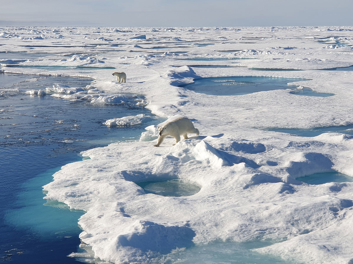
Figure 4.4 Polar bears in the marginal ice zone north of Svalbard in August 2023.
Photo: Cecilie von Quillfeldt, Norwegian Polar Institute
Many of the fish, seabird and marine mammal species found in this area are vulnerable, fragile, slow to recover and/or red-listed. One of the most obvious impacts of climate change in the Arctic is the temporal and spatial reduction in sea ice extent. The long-term trend that is being observed is a gradual withdrawal northwards of the limit of the sea ice in both summer and winter, but there are large interannual variations. The ice cover is also becoming thinner. Climate change is a growing threat to a range of species and habitat types found in the designated Marginal Ice Zone that are dependent on the sea ice.
Multi-year Arctic sea ice is a habitat type that is found in the northernmost parts of the Marginal Ice Zone, north of Svalbard. It comprises the multi-year ice cap that covers the central Arctic Ocean, and the marine organisms (ice flora and ice fauna) directly associated with it. Multi-year Arctic sea ice is considered to be a critically endangered habitat because of the substantial decline in its extent. The area of multi-year ice around Svalbard has been greatly reduced because the ice is melting more quickly around the edges of the Arctic Ocean than in central parts. The marginal ice zone is also considered to show a high degree of naturalness as defined by the EBSA criteria, with the exception of impacts associated with climate change. This is because there is little or no human disturbance or human-induced degradation as a result of activity within the area.
Within the Marginal Ice Zone, the vulnerability of Arctic zooplankton species, benthic communities, ice biota, early life stages of fish, seabirds and Arctic ice-associated marine mammals is assessed as high.
The benthic fauna shows high vulnerability to bycatches, alien species and habitat loss through sealing of the substrate. Early life stages of fish show high vulnerability to pollution, particularly oil spills. Seabirds show high vulnerability to bycatches, disturbance due to human presence, litter and all forms of pollution. Marine mammals show high vulnerability to selective species extraction and pollution.
All species groups except fish show high vulnerability to climate change. For some species groups, positive impacts are expected on certain species and negative impacts on others, but the impacts on seabirds will be exclusively negative.
The distribution of vulnerable species within the Marginal Ice Zone varies through the year and between years, as a result of variations in ice extent and other physical conditions, biological production and the occurrence and distribution of migratory species.However, regardless of the time of year, the entire zone is important for various species and biological processes.
Ice extent in the Barents Sea is showing a negative long-term trend, and this is expected to continue in response to anthropogenic climate change. As a result, the ecosystem components that are used as a basis for delimiting the Marginal Ice Zone are likely to disappear gradually from the southernmost parts of the area, and in a few years’ time it will probably be necessary to update the delimitation of the Marginal Ice Zone using newer ice data.
Eggakanten North (BH3)
Eggakanten North stretches from the boundary of the Norwegian Sea management plan area northwards to the ice-covered sea north and west of Svalbard, including the Yermak Plateau. It is contiguous with Eggakanten South in the Norwegian Sea management plan area. Oceanographic processes are comparable along the whole length of the Eggakanten area, where there is a sudden drop from the continental shelf to deeper waters. However, environmental conditions change rapidly where the slope is steep. There is a strong northerly Atlantic current along the Eggakanten area.
Heat transport in the Atlantic current off the Norwegian coast and the meeting with cold, fresher Arctic water flowing from the north strongly influence fluctuations in sea temperatures in this area. The west Spitsbergen current carries warm Atlantic water along the continental slope west and north of Spitsbergen and keeps this area ice-free for much of the year, while sea ice normally covers parts of the area north of Spitsbergen (southeastern part of the Yermak Plateau) and further northeast.
There is a generally elevated level of biological production and high biodiversity in the Eggakanten area. Eggakanten North supports a number of vulnerable habitat types including bathyal seapen communities, Radicipes coral gardens, Lophelia coral reefs, hard-bottom coral gardens and deep Arctic sponge aggregations. The only site where Radicipes is known to occur in Norwegian waters is a small area north of the Tromsøflaket bank area. There are several Lophelia coral reefs in the southern part of Eggakanten North. The Røstrevet reef complex, the world’s largest known reef of the stony coral Lophelia pertusa (now called Desmophyllum pertusum), lies in the Eggakanten area, in the upper part of a major underwater landslide. Particularly in steep parts of the continental slope, where environmental conditions change rapidly over short distances, there may be small areas of high biodiversity.
Vertical mixing processes that enhance primary production locally, and northwards transport of nutrient- and biomass-rich Atlantic water are two reasons why productivity is high in Eggakanten North and why the area is also very important for productivity in other parts of the Barents Sea, the waters around Svalbard and the Arctic Ocean.
Eggakanten North includes the most important spawning and breeding grounds for many commercially and ecologically important fish species. These include cod, haddock, herring, beaked redfish and golden redfish (endangered), and also Greenland halibut, which in Norway only spawns along the northern section of the Eggakanten area. This is also the only area in Norwegian waters where several Arctic species of eelpouts can be found.
For seabirds, Eggakanten North is an important summer feeding area. This is particularly true of pelagic feeders, including several threatened species, during the breeding season. It is also an important feeding area for whales such as fin and blue whales for which zooplankton is an important part of the diet.
In this area, the vulnerability of the benthic fauna, early life stages of fish, Arctic and ice-associated seabirds, and some species of toothed whales to various pressures is assessed as high.
The benthic fauna shows high vulnerability to bycatches, abrasion and habitat loss through sealing of the substrate. Early life stages of fish show high vulnerability to pollution and the extraction of non-living resources. Seabirds show high vulnerability to bycatches, disturbance due to human presence, litter and pollution, including oil spills. Marine mammals show high vulnerability to pollution.
In addition, the benthic fauna and seabirds are the species groups that are most vulnerable to climate change. Climate change may have either positive or negative impacts depending on species’ individual temperature preferences.
Coastal Zone Finnmark (BH4)
This area is situated north of the coast of Finnmark county, on the edge of the continental shelf, and stretches from the Tromsøflaket bank area to the Russian border and 100 km out to sea. The coastal current, which follows the continental slope off the coast, transports plankton and fish eggs and larvae eastwards through the area. The Coastal Zone Finnmark includes a number of fjords opening towards the Barents Sea where environmental conditions are very distinctive.
This is one of the most important breeding areas for seabirds on the Norwegian mainland, and a large proportion of a number of Norwegian seabird populations feed on the fish larvae and fry that are transported through the area. Depending on the availability of food, seabirds may feed close to the breeding colonies or further out to sea, up to at least 100 km from the breeding colonies. This is also an important wintering area for sea diving ducks, divers and gulls from other parts of the Arctic. The Steller’s eider is the rarest diving duck in the world, and 5–10 % of the world population winters in the Varangerfjorden. Norwegian and Russian populations of common eider, king eider and other sea ducks also use the coastal zone Finnmark during the moult.
The area includes Gjesværstappan, a group of islands that is home to what is now Norway’s largest puffin colony, numbering more than 300 000 breeding pairs. It is also important for other threatened or declining seabird species, such as the common guillemot (critically endangered), razorbill (vulnerable) and kittiwake (endangered), and for the large gull species, which are now declining.
The Coastal Zone Finnmark is one of the main spawning areas for capelin, a key species in the ecosystem. Capelin spawn on the seabed from early March. The larvae drift in the upper 50 m of the coastal current, moving eastwards and then northwards out into the Barents Sea together with large quantities of plankton, eggs and larvae of other fish species.
There are several important breeding sites for grey seals and areas of important habitat for common seals in the Coastal Zone Finnmark. Cold-water corals are to be found in shallow water, including some near the coast.
Inner parts of the Porsangerfjorden are very cold, providing Arctic conditions and supporting ecosystems including species that otherwise are only found further north in the Barents Sea, such as polar cod.
In the Coastal Zone Finnmark, the vulnerability of eelgrass, benthic communities, early life stages of fish, seabirds and some marine mammals to various pressures is assessed as high.
Seaweed, kelp and eelgrass show high vulnerability to the extraction of non-living resources. Benthic communities are considered to be vulnerable to bycatches, abrasion, alien species and habitat loss through sealing of the substrate. Early life stages of fish are vulnerable to pollution, including oil spills, and the extraction of non-living resources. Seabirds show high vulnerability to bycatches, disturbance due to human presence, litter and pollution, including oil spills. Marine mammals show high vulnerability to bycatches, selective species extraction, litter, pollution and oil spills.
The vulnerability of benthic communities and seabirds to climate change is high. For seabirds, the impacts of climate change will be negative only, whereas the changes may have either positive or negative impacts on benthic communities, depending on the species involved.
Senja–Tromsøflaket Bank Area (BH5)
This bank area lies near the edge of the continental shelf in the southwestern part of the Barents Sea, stretching roughly from north of the island of Senja to Hammerfest. The Senja–Tromsøflaket Bank Area also includes Lopphavet, where the coastal current flowing from further south splits into two branches, one of which continues close to land while the other follows the topography around the Tromsøflaket bank area. This lengthens the water residence time around the Tromsøflaket, making it a retention area.
This area (previously called the Tromsøflaket bank area) has been extended northwards to include rich benthic communities, and further towards the coast to provide better coverage of seabird feeding areas and important fish spawning grounds. It has also been extended southwards to include an area that was included in the Coastal Zone Lofoten in the expert group’s proposal.
The variability of the coastal current is closely linked to variations in wind, and the current is stronger in winter than in summer. In spring and summer, when the water in the area is stratified, winds strongly influence the surface circulation. This influences water exchange between the continental shelf and the open ocean, and the wind direction is crucial for drift trajectories and the residence time of the water. Tidal currents also contribute to water exchange between the continental shelf and the deep sea in this area.
The Senja–Tromsøflaket Bank Area plays a particularly important role in the transport of plankton and fish eggs and larvae that are carried eastwards and northwards into the Barents Sea. The current system in this area creates an eddy, which means that the water masses have a long retention time.
There are rich benthic communities in the Tromsøflaket bank area. These include the world’s northernmost cold-water coral reef complex, Korallen, off Sørøya island, and extensive soft-bottom sponge aggregations. In the Lopphavet area, there are deep trenches and large coral communities that provide nursery areas for several fish species.
Capelin spawn along the coast in March-April, and the eggs adhere to the bottom substrate for 3–4 weeks. Once the larvae are hatched, they float up to the surface and are transported by the current. In the spring and early summer months, large quantities of fish larvae (herring, cod, haddock, saithe, redfish and capelin) are transported through the Senja–Tromsøflaket Bank Area in the upper 50 metres of the water column, and find rich feeding in the shallow bank areas. Each summer, a large proportion of the year class of cod and haddock passes through the area. The spawning area for golden redfish stretches along the edge of the continental shelf and northwards and eastwards into the Barents Sea, along the entire length of the designated Senja–Tromsøflaket Bank Area. The northern part of the Tromsøflaket bank area is an important spawning ground for several species. Coastal cod spawn in more sheltered areas in the fjords. Some spawning grounds for coastal cod are within the designated area. However, the landward boundaries of particularly valuable and vulnerable areas near the coast are largely determined by the occurrence of ecosystem components associated with the management plan area further out to sea, so that coastal cod spawning areas are not fully included in the near-coastal areas that have been designated.
The concentration of planktonic organisms results in very rich food supplies for a number of breeding and wintering seabirds, including several red-listed species. There are nationally important breeding colonies of puffin and common guillemot, and historically also of kittiwake. One of Norway’s largest puffin colonies is on Sørøya island, and accounts for about a quarter of the Norwegian population. Some of Norway’s largest breeding colonies of shag are also in this area, and it is an important wintering area for sea diving ducks, divers and gulls from other parts of the Arctic. In winter, whales, particularly orcas and humpback whales, follow the herring as they move into the fjords for spawning. Coastal seals feed in the area all year round.
In the Senja–Tromsøflaket Bank area, the vulnerability of eelgrass, benthic communities, early life stages of fish, seabirds and some marine mammals to various pressures is assessed as high.
Benthic communities show high vulnerability to bycatches, abrasion and habitat loss through sealing of the substrate. Early life stages of fish are vulnerable to pollution, including oil spills, and the extraction of non-living resources. Seabirds show high vulnerability to bycatches, disturbance due to human presence, litter, pollution, including oil spills, and alien species. Marine mammals show high vulnerability to bycatches, selective species extraction, and pollution, including oil pollution.
In addition, the vulnerability of benthic communities and seabirds to climate change is high. However, the changes may have either positive or negative impacts, depending on the species involved.
Coastal Zone Lofoten (BH6)
The area designated as the Coastal Zone Lofoten stretches from the waters around the Lofoten Islands (including the Vestfjorden) and northwards to Troms county. The continental shelf is narrow in this area, and the continental slope is very steep. There are several markedly shallower bank areas on the shelf, including Røstbanken, Sveinsgrunnen and Malangsgrunnen, and deeper trenches such as Bleiksdjupet and Andfjorden.
The main elements of the current system are the coastal current along the continental shelf and the strong, one-way, narrow Norwegian Atlantic current along the continental slope. The coastal current influences and is influenced by the water masses around skerries and in fjords, as determined by the topography, including sills and deep basins.
The narrow continental shelf and strong, narrow coastal current result in the concentration of zooplankton, fish eggs and larvae and other organisms that are transported with the current.
The Coastal Zone Lofoten is a very important spawning area for both cod and haddock in late winter and spring. It is also extremely important as a transit zone for eggs, larvae and fry of these species, and also for herring. The area includes the Vesterålen banks, which provide some of the most important breeding areas for golden redfish (endangered), and are also important to a number of other fish species. The coastal zone is also an important wintering area for Norwegian spring-spawning herring, although in some periods they concentrate in other fjord systems further north. Spring-spawning herring are an important part of the diet of orcas. The waters around the Lofoten Islands are an important feeding area for basking sharks, an endangered species.
The Coastal Zone Lofoten includes a wide variety of marine habitat types and marine landscapes. One of the world’s largest cold-water coral reef complexes, Røstrevet and Hola, is within the designated area. In Andfjorden there are bamboo coral (Isidella lofotensis) gardens and sublittoral seapen communities. The Steinaværrevet reef in Andfjorden and Bleiksdjupet, one of Europe’s largest underwater canyons, support distinctive coral habitats and sponge aggregations.
Most seabird species present in Norway breed in this area, and it is also one of the most important feeding areas for seabirds in the country, both in winter and in the breeding season, making it nationally important. The Coastal Zone Lofoten is an important wintering area for coastal species such as eider, cormorant and shag. The common guillemot, puffin and kittiwake, which breed in the large seabird colonies in the area, are all threatened species.
Around Øksnes and Andøya, there is important habitat for common seals.
The importance of the area varies through the year for many species, but because it is so species-rich, it is important for one or more groups of fish, seabirds, benthic animals and marine mammals throughout the year.
In this area, the vulnerability of the benthic fauna, early life stages of fish, seabirds, and some marine mammals to various pressures is assessed as high.
The benthic fauna is particularly vulnerable to bycatches, abrasion and habitat loss through sealing of the substrate. Early life stages of fish are vulnerable to pollution and the extraction of non-living resources. Seabirds show high vulnerability to bycatches, disturbance due to human presence, litter, all types of pollution, and alien species, including mink (during the breeding season). Marine mammals show high vulnerability to bycatches, selective species extraction and pollution, including oil spills.
In addition, the vulnerability of the benthic fauna and seabirds to climate change is high. However, the changes may have either positive or negative impacts, depending on the species involved.
The Central Barents Sea (BH7)
The area designated as the Central Barents Sea includes the southern part of the Central Bank and the Thor Iversen Bank, and the deeper basin southeast of them in the direction of Novaya Zemlya.
The Norwegian Atlantic current enters from the southwest and splits in the southwestern part of the area, so that two branches flow eastwards south of the Central Bank. In addition, colder Arctic water, and in winter ice, flow into the northern part of the area.
The Central Barents Sea is used by seabirds from the breeding colonies all around the Barents Sea, both on the Arctic islands and on the mainland. The area is particularly important after the breeding season for seabirds such as common and Brünnich’s guillemots, which migrate by swimming into the area to feed while they are moulting and cannot fly. It is also an important wintering area for these species. In addition, the designated area covers part of the autumn and winter distribution of puffins and glaucous gulls, and waters used by the kittiwake populations in spring. These species use larger parts of the Barents Sea, but congregate in the designated Central Barents Sea for large parts of the year. A number of seabirds, including common and Brünnich’s guillemot, puffin and fulmar, are red-listed.
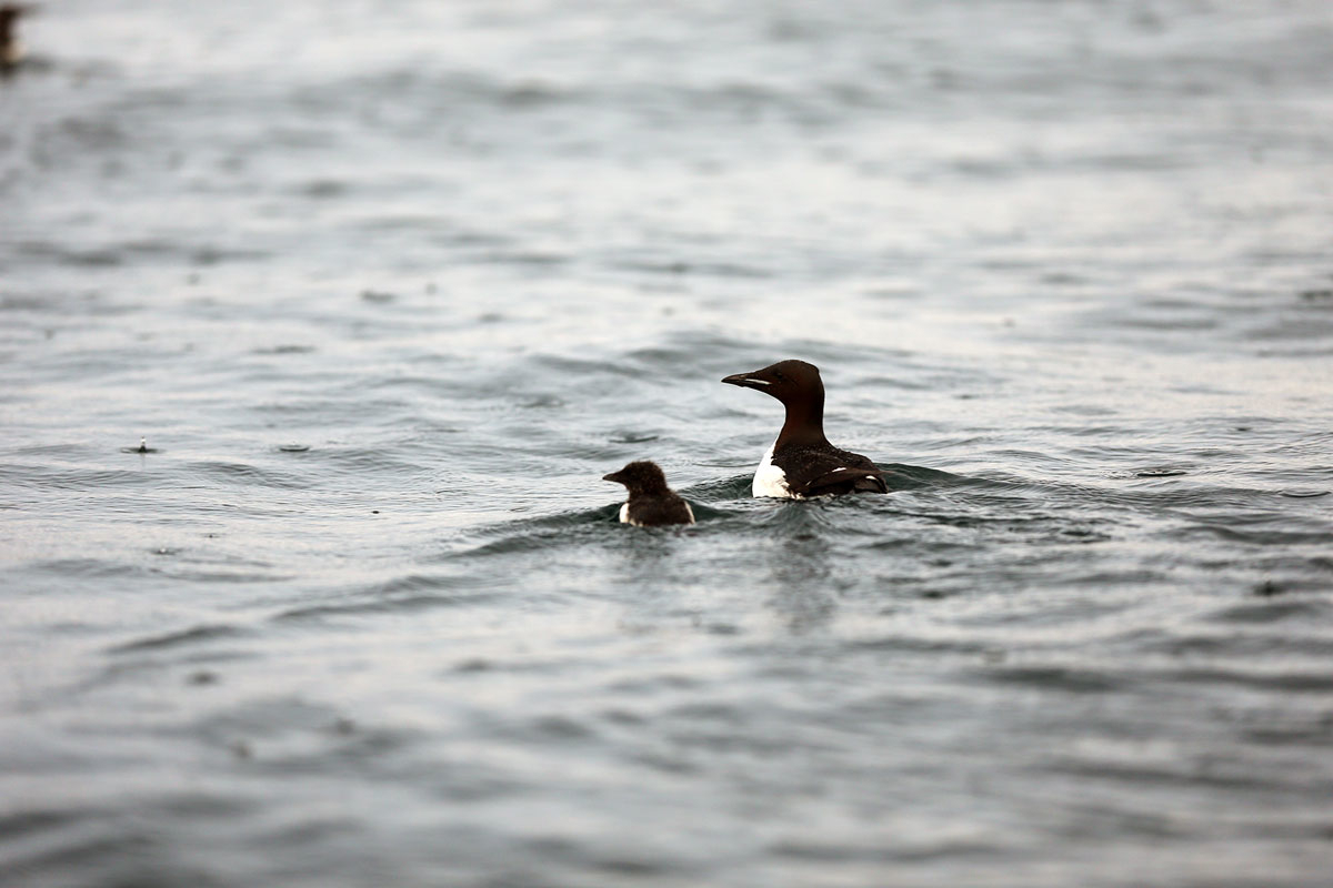
Figure 4.5 Brünnich's guillemot with a chick on swimming migration.
Photo: Hallvard Strøm, Norwegian Polar Institute
In spring and summer, the ocean currents carry zooplankton and fish eggs, larvae and fry into the area. It is therefore a feeding area for adult fish, seabirds and to some extent marine mammals. Cod and haddock larvae settle on the bottom in winter, while larvae of other species remain in the surface water layers. The species richness of fish is higher in the central part of the Barents Sea than in the surrounding areas.
There are large Haploops communities on the Thor Iversen Bank. These are rare and unusual amphipods that live in small, self-built tubes.
Overall, the area is considered to score high on the uniqueness criterion, and is important because it is a particularly attractive feeding area for threatened seabird species during the moulting period in the Atlantic part of the Barents Sea, and is also of great significance for biological productivity and diversity.
In this area, the benthic fauna, early life stages of fish, seabirds and toothed whales are considered to be particularly vulnerable to various pressures.
Benthic communities show high vulnerability to bycatches, abrasion, alien species and habitat loss through sealing of the substrate. Early life stages of fish show high vulnerability to pollution, including oil pollution. Seabirds show high vulnerability to bycatches, disturbance due to human presence, litter and pollution, including oil pollution. Marine mammals show high vulnerability to pollution.
The benthic fauna and seabirds in particular show high vulnerability to climate change. However, the changes may have either positive or negative impacts, depending on the species involved.
4.1.4 Particularly valuable and vulnerable areas in the Norwegian Sea
On the basis of the scientific review of the particularly valuable and vulnerable areas, changes have been made to the list for the Norwegian Sea management plan area. Three of the areas – Sea Ice, Fram Strait (NH1), the West Ice (NH2), and Eggakanten South (NH5), are unchanged. The Mid-Atlantic Ridge (NH4) has been identified as a new particularly valuable and vulnerable area. It partly overlaps the Arctic front, which is no longer included in the list. The Coastal Zone Norwegian Sea North (NH6) corresponds to the northern part of the area called Coastal waters Norwegian Sea in 2020, somewhat expanded, and also includes the Iverryggen reef, Sklinna bank, Frøan archipelago and Sula reef, and the Remman archipelago, which were designated as separate areas in 2020. The Coastal Zone Norwegian Sea South (NH7) corresponds to the southern part of the Coastal waters Norwegian Sea, again somewhatexpanded, and also includes the Møre banks. Finally, Norwegian Sea Deep Waters (NH8) has been designated as a particularly valuable and vulnerable area for the first time.
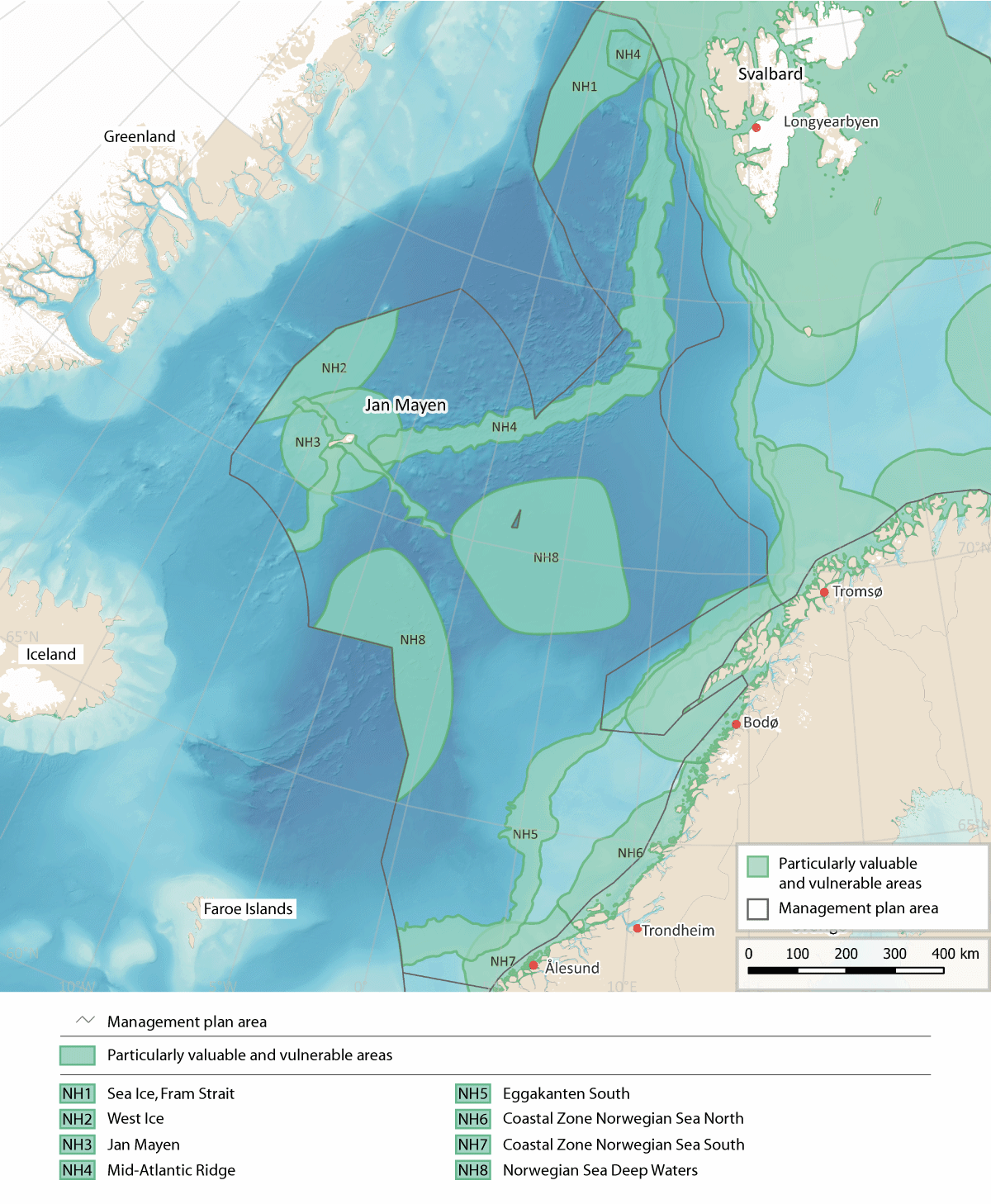
Figure 4.6 Particularly valuable and vulnerable areas in the Norwegian Sea management plan area.
Source: Forum for Integrated Ocean Management/Institute of Marine Research/Norwegian Mapping Authority/ GEBCO Compilation Group (2023)
Sea ice, Fram Strait (NH1)
This area in the eastern part of the Fram Strait is dominated by sea ice transported southwards from the Arctic Ocean by ocean currents. The ice in this area is a mixture of ice of different origins, and includes a wide variety of ice types. In the eastern part of the area, the ice is similar to that in the Barents Sea, while there is older, thicker ice further north and west. Sea Ice, Fram Strait is a westerly continuation of the Marginal Ice Zone (BH2), and updating the time series for sea ice extent has only resulted in small adjustments of the delimitation of the area.
Primary production in spring starts earlier in the ice than in open water, which prolongs the productive season in this area. In some periods, phytoplankton production and the quantity of biomass will therefore be higher where ice is present than in nearby areas of open water.
The sea ice is important as the habitat of the ice biota, which includes a range of community types including a large number of species and many different species groups. Species that live in multi-year ice are particularly vulnerable to climate change. The spatial reduction in sea ice extent, delayed ice formation and early ice-melt result in a shorter productive season for the ice biota. However, thinner ice can improve light conditions, which may increase production. The proportion of multi-year ice in the Fram Strait is higher than in the Barents Sea, making this area particularly important for species that spend their entire life cycle within or attached to the underside of the ice (for example rotifers and small crustaceans such as amphipods and copepods).
Atlantic zooplankton that is transported with Atlantic water from the Norwegian Sea to the Arctic via the Fram Strait may be an important food source for mesopelagic plankton predators in the Arctic Basin.
The marginal ice zone in the Fram Strait is important for ivory gulls (vulnerable) both before the start of the breeding season and in autumn. Both Greenland whales (critically endangered) and narwhals (vulnerable) use the drift ice areas in the Fram Strait all year round. The Spitsbergen population of bowhead whale breeds in the northwesterly part of the Fram Strait. Regional extinction of these species would mean the loss of important biodiversity.
There is very little direct pressure from human activity in areas of sea ice and the marginal ice zone.
The vulnerability of the benthic fauna, ice biota, seabirds, and marine mammals (toothed whales and polar bears) to various pressures is assessed as high in this area. Seabirds show high vulnerability to bycatches, litter, and pollution, including oil pollution. Marine mammals (toothed whales and polar bears) show high vulnerability to pollution. Ice biota, seabirds, marine mammals and polar bears show high vulnerability to climate change, which will generally have negative impacts on these species groups.
The West Ice (NH2)
The area designated as the West Ice covers the sea ice north and west of Jan Mayen. Updating the time series for sea ice extent has only resulted in small adjustments of the delimitation of the area. This area of drift ice is influenced by the cold south-flowing East Greenland current, which carries ice and cold water from the Arctic Ocean. The West Ice varies considerably in area from year to year, and may be situated much further to the east in spring. There has been a downward trend in sea ice extent in recent decades.
The West Ice is a core breeding area for hooded seals (endangered), and also an important breeding and feeding area for harp seal. Both these species are endemic to the North Atlantic. Pup production in both species is dependent on the sea ice, since they whelp on the ice that forms in the area in March-April. The decline in the hooded seal population may be related to the reduction in drift ice and the fact that there are fewer, thinner drift ice floes.
There is little pressure from human activities in the West Ice, although a small harvest of seals is taken in the area. Marine mammals (seals) show high vulnerability to various pressures, particularly to pollution in the form of oil spills. Seals also show high vulnerability to climate change.
Jan Mayen (NH3)
Topographical conditions in the area designated as Jan Mayen are very distinctive because these waters are above the Mid-Atlantic Ridge. Cold water from the East Greenland current and warmer water from the North Atlantic Current meet in this area.
The area is particularly valuable for seabirds. Jan Mayen itself is of outstanding importance in Norway as a seabird breeding area. There are 18 breeding species and 22 different seabird colonies, holding more than 300 000 pairs of seabirds in total. The most numerous species are fulmar, little auk and Brünnich’s guillemot. Razorbills, black guillemots, common guillemots and kittiwakes also breed, and in addition more southerly species such as lesser black-backed and herring gulls. Both Arctic and great skuas are also fairly numerous. The pelagic species that dominate on the island generally feed in areas up to 100 km out to sea from the colonies. Several of the seabird species that breed on Jan Mayen are showing an overall decline or are red-listed, but the Jan Mayen colonies appear to be relatively resilient. The island may thus serve as a refugium for species that are declining elsewhere.
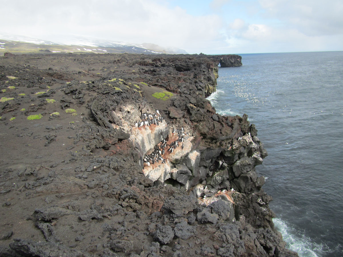
Figure 4.7 Skrinnodden/Splittodden, geologically one of the youngest areas of Jan Mayen. Five of the six species of auks found on the island breed here.
Photo: Erlend Lorentzen, Norwegian Polar Institute
Nutrient-rich waters support high, stable biological production in the Jan Mayenarea. Zooplankton associated with a variety of habitats is found here, and species diversity may therefore be high. High levels of zooplankton biomass have been recorded in the area.
The convergence of different ocean currents on the Mid-Atlantic Ridge provides suitable conditions for many different fish species. The eelpout Lycenchelys platyrhina, for example, has not been registered anywhere else in Norwegian waters.
Benthic communities in a 4-km wide belt near the island of Jan Mayen are still showing the effects of the volcanic eruption in 1970, which covered subsea areas down to a depth of 30 m with lava. This is the only area in Norwegian waters where it is possible to follow the reestablishment of shallow-water coastal benthic communities after a volcanic eruption.
Because of its remote position, there is very little pressure from human activity in the Jan Mayen area.
The vulnerability of the benthic fauna and seabirds to various pressures is assessed as high in this area. Benthic communities show high vulnerability to bycatches, selective species extraction, abrasion and habitat loss through sealing of the substrate. Seabirds show high vulnerability to bycatches, disturbance due to human presence, litter, pollution, and oil pollution. Climate change may have either negative or positive impacts on the benthic fauna depending on the species that are affected, but the impacts on seabirds will be exclusively negative.
The Mid-Atlantic Ridge (NH4)
The area designated as the Mid-Atlantic Ridge consists of a number of ridges and fracture zones in the northern Norwegian Sea, stretching over a considerable distance from west of Svalbard to the waters around Jan Mayen. At the northern end, near Svalbard, the ridge meets Molloydypet, the deepest basin in Norwegian waters. The complex topography generates enhanced vertical mixing along the ridge. There are also scattered active and inactive hydrothermal vent fields in the area.
There are a number of active hydrothermal vent fields, for example Loki’s Castle, and also inactive vent fields both along the rift valley of the Mid-Atlantic Ridge and in the Jan Mayen fracture zone. Both active and inactive vent fields support a varied fauna and microorganisms that are specialised to withstand high temperatures and that are only found in association with hydrothermal vent fields. Many species are chemosynthetic or have a symbiotic relationship with chemosynthetic microorganisms. Chemosynthetic species use chemical reactions to convert inorganic substances discharged from the hydrothermal vents into nutrients. This means that they are not dependent on a food chain starting with sunlight and primary production, neither of which exists in deep water. The species found here and the species composition of these hydrothermal vent communities are both quite distinct from those found around hydrothermal vents elsewhere in the world.
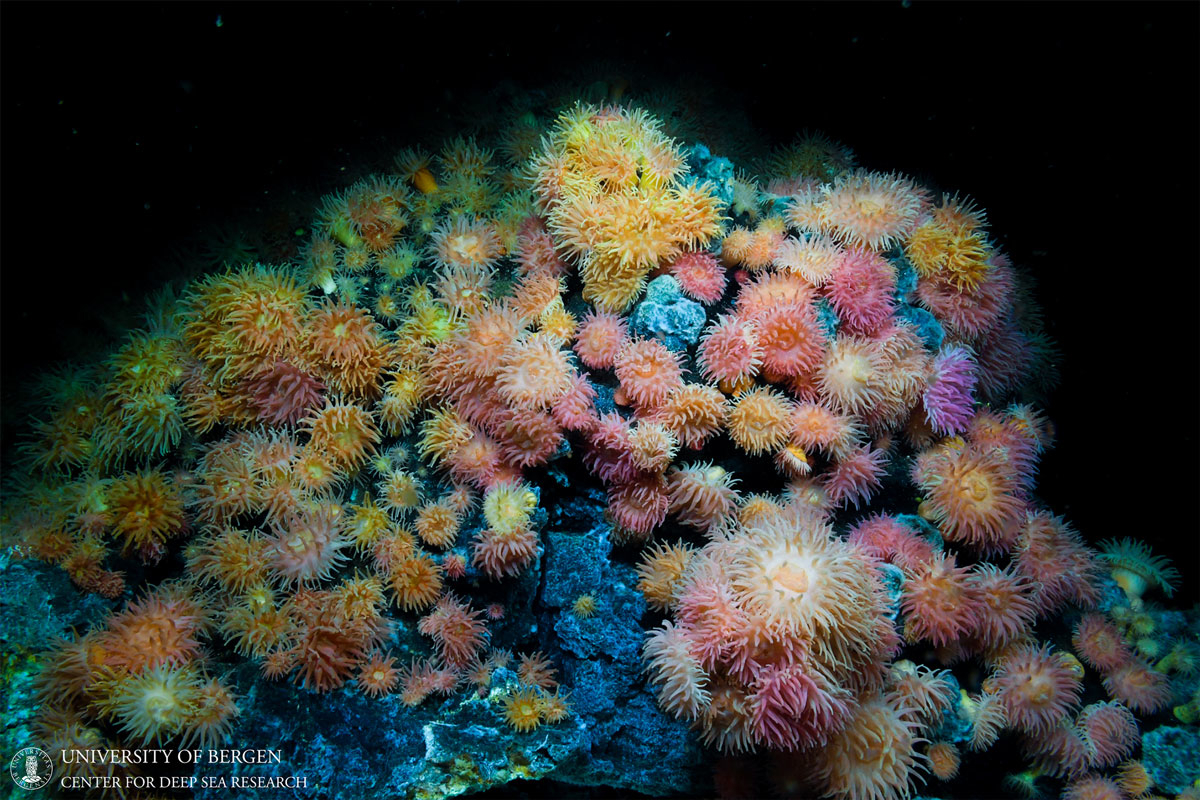
Figure 4.8 Sea anemones growing at a depth of about 500 m near the Jan Mayen hydrothermal vent fields on the Mid-Atlantic Ridge.
Photo: Centre for Deep Sea Research, University of Bergen
This is an area of particularly high productivity, with benthic communities dominated by sponges and corals and with seamounts that function as spawning and nursery areas for populations of slow-growing fish. These habitats are all included in the OSPAR List of Threatened and/or Declining Species and Habitats. In addition, the area supports hard-bottom coral gardens that are classified as near-threatened in Norway’s Red List of ecosystems and habitat types. These are typically living habitats that are slow-growing, fragile, and slow to recover, and that support distinctive species assemblages. A number of species are dependent on a specific bottom substrate. Several other vulnerable habitat types are also to be found in the new Jan Mayen designated area.
The Mid-Atlantic Ridge overlaps to a large extent with the Arctic front. High concentrations of phyto- and zooplankton have been observed near the Arctic front, and this has been explained by physical processes in the area. The Arctic front is important as a habitat boundary for various species, and is an area where large numbers of species at different levels in the food chain are concentrated by the ocean currents.
There are indications that the Mid-Atlantic Ridge maybe an important summer feeding area for bottlenose whales.
The seabed is relatively undisturbed in the deeper parts of this area. The benthic fauna shows high vulnerability to physical disturbance and habitat loss through sealing of the substrate. Vulnerability to climate change is also high. However, the impacts of climate change may be either negative or positive for different species of the benthic fauna.
Eggakanten South (NH5)
The area designated as Eggakanten South includes the entire continental slope and extends about 10 km on to the continental shelf. Its width varies depending on the steepness of the continental slope. The continental slope results in a strong, one-way, narrow Norwegian Atlantic current along the continental slope. The water temperature declines northwards as a result of heat loss to the atmosphere and mixing with adjacent water masses. The ocean floor rises towards the continental shelf as a steep wall interrupted by ravines and fissures.
Like Eggakanten North, this area supports a number of vulnerable habitats: bathyal seapen communities, Lophelia coral reefs, hard-bottom coral gardens and deep Arctic sponge aggregations. There are more known coral reefs in Eggakanten South than in Eggakanten North. The only reliable observation of Madrepora oculata reefs in Norwegian waters is from Storneset, towards the southern end of Eggakanten South.
Large quantities of the mesopelagic fish species glacier lantern fish (Benthosema glaciale), silvery lightfish (Maurolicus muelleri) and spotted barracudina (Arctozenus risso) are found in the Eggakanten area and adjacent waters. This is probably a more important spawning area for these species than more westerly parts of the Norwegian Sea.
Eggakanten South is also an important spawning area for haddock and several deep-water species, including golden redfish (endangered) and greater argentine. Redfish also show a preference for the distinctive coral reefs, which are slow-growing and slow to recover.
The availability of various life stages and sizes of plankton and fish makes this an important feeding area. The abundance of zooplankton provides favourable conditions for the survival of early life stages of many fish species that drift northwards along the edge of the continental shelf, including Norwegian spring-spawning herring, cod, and golden and beaked redfish. This is also important as a feeding area for pelagic seabirds, particularly during the breeding season. These include several red-listed species, for example common guillemot and puffin, which feed on fish larvae drifting in the current.
The edge of the continental shelf and the upper part of the continental slope also form an important feeding area for sperm whales and hooded seals. The seabed in the deeper parts of Eggakanten south appears to be completely undisturbed.
In this area, the vulnerability of the benthic fauna, early life stages of fish and marine mammals (seals and toothed whales) to various pressures is assessed as high. The benthic fauna shows high vulnerability to bycatches, abrasion and habitat loss through sealing of the substrate. Early life stages of fish show high vulnerability to pollution, including oil spills. Toothed whales show high vulnerability to pollution. Both the benthic fauna and seals show high vulnerability to climate change. However, the impacts of climate change on the benthic fauna may be either negative or positive, while the impacts on seals will be negative.
Coastal Zone Norwegian Sea North (NH6)
This area includes a large number of inlets and sounds lying between islands and skerries. Parts of the area extend far from land towards the Eggakanten area, and feature eddy fields that lengthen the residence time of the water and create retention areas. The area covered by the Coastal Zone Norwegian Sea North includes the Halten bank, Sklinna bank, Frøan archipelago and Sula reef, Coastal waters Norwegian Sea (northern part) and Remman archipelago, all of which were designated as particularly valuable and vulnerable areas in the previous white paper.
Overall, the area supports a high diversity of habitats and species, especially where there are kelp forests. It includes very important spawning grounds for a number of fish species, particularly commercially important species such as Northeast Arctic cod and Norwegian spring-spawning herring, but also Norway pout and golden redfish (endangered). Spawning takes place in late winter and spring, and the larvae drift northwards in late spring and early summer. Plankton become concentrated in retention areas, resulting in higher levels of biomass on which fish larvae and fry can feed. This is also an important feeding area for basking shark (endangered) and porbeagle (vulnerable).
The Coastal Zone Norwegian Sea North is an important breeding and feeding area for seabirds, particularly for coastal species such as common eider, shag, cormorant, black guillemot, and great and lesser black-backed gull, but also for some pelagic species such as kittiwake and Arctic skua. Several of these are red-listed. The shallow-water parts of the area are also important moulting areas for common eider and important wintering areas for species including common eider, black guillemot, shag, cormorant, large gulls, divers and grebes. One of the world’s largest shag colonies is on the Sklinna archipelago. Most of the Norwegian population of lesser black-backed gull (subspecies Larus fuscus fuscus) is to be found in this area. This subspecies has been suffering a prolonged period of decline.
There are several important breeding sites for common seals in the area. Although the total population of common seals in Norway has been increasing in recent years, there has been a certain decline in Trøndelag county, including the Froan archipelago.
The area includes a large number of coral reefs and other vulnerable habitat types, most of which are intact and shown no signs of being damaged by bottom fishing. There are coral reefs both close to the coast and further out on the continental shelf, with concentrations in the Sula reef and Iverryggen reef area.
In this area, the vulnerability of seaweed, kelp and eelgrass, the benthic fauna, early life stages of fish, and seabirds and marine mammals (seals and toothed whales) to various pressures is assessed as high.
Seaweed, kelp and eelgrass show high vulnerability to the extraction of non-living resources (shell sand). The benthic fauna shows high vulnerability to bycatches, abrasion and habitat loss through sealing of the substrate. Early life stages of fish show high vulnerability to pollution, including oil pollution, and the extraction of non-living resources. Seabirds show high vulnerability to bycatches, disturbance due to human presence, litter, pollution, including oil pollution, and alien species. Marine mammals show high vulnerability to bycatches, selective species extraction, and pollution, including oil pollution.
Climate change will have both positive and negative impacts. The impacts will be largely positive for seaweed, kelp and eelgrass and for fish. The benthic fauna and seabirds show high vulnerability to climate change, and the impacts on seabirds will be exclusively negative. The changes may have either positive or negative impacts on the benthic fauna, depending on the species involved.
Coastal Zone Norwegian Sea South (NH7)
Atlantic water and the Norwegian coastal current meet in the Coastal Zone Norwegian Sea South, and as a result the waters are particularly nutrient-rich. The topography is very distinctive, with only a short distance from the edge of the continental shelf to the mainland in the southernmost part of the area, and shallow underwater plains, islands and skerries in the northern part. This creates retention areas where the water has a relatively long residence time. The luxuriant kelp forests in the area also influence current patterns. The Coastal zone Norwegian Sea south includes theMøre banks, Coastal waters Norwegian Sea (southern part), and Bremanger–Ytre Sula, all of which were designated as separate areas in the previous white paper.
The Møre banks are a core area for spawning and early life stages of Norwegian spring-spawning herring and saithe, and are also important for cod (coastal cod and historically for Northeast Arctic cod), haddock, Norway pout and golden redfish (endangered). They are also used by the first-feeding stage of herring, cod, saithe and other fish larvae. Coastal cod spawn both in more exposed coastal waters and in sheltered fjord arms, relatively close to the nursery areas used by the larvae. The Møre banks are also important, especially in summer, for the basking shark, a particularly vulnerable species that exhibits late sexual maturity, low fecundity and slow growth. Records do not show generally enhanced levels of zooplankton production in the area as a whole. However, there may be large local variations, since plankton is concentrated in retention areas, where biomass is higher. The zooplankton in the area is important for fish larvae and fry.
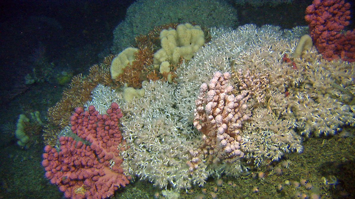
Figure 4.9 Coral reef in Stjernsund at a depth of about 250 m.
Photo: Institute of Marine Research
The Coastal Zone Norwegian Sea South is an important breeding, moulting, passage and wintering area for seabirds. A number of localities within the area are of national importance as breeding sites and/or moulting areas. This is an important feeding area for species including gannet, common guillemot, puffin and razorbill. A number of coastal species also feed in the shallower parts of the area, and there are considerable numbers of common eider, black guillemot, shag, herring gull and lesser black-backed gull both in the breeding season and in winter. In the breeding season, species diversity in the seabird colonies on Runde island is higher than anywhere else in Norway, and various threatened species breed here. The largest puffin colony south of Røst is also on Runde, and the gannet colony on the island accounts for more than 50 % of the total Norwegian population. The Coastal Zone Norwegian Sea South is also an important wintering area for little auk and yellow-billed diver.
There are colonies of common seals throughout the area, the largest being at Sandøy and Haram in Møre og Romsdal county.
A number of vulnerable habitat types are also to be found in the area, including coral reefs, hard-bottom coral gardens, seapen communities and hard-bottom sponge aggregations. The combination of the current system, the availability of zooplankton, and the presence of sponge aggregations and coral reefs, which are species-rich in themselves and provide a habitat for many pelagic animals, results in high species diversity. Laminaria hyperborea kelp forests are very valuable; they provide shelter and feeding areas for early life stages of benthic animals, and moderate wave action and ocean currents, thus resulting in the retention of water, plankton and fish larvae. Kelp forests are important for many declining species of coastal seabirds, for example for auks that lay only one or a few eggs a year.
In this area, the vulnerability of seaweed, kelp and eelgrass, the benthic fauna, early life stages of fish, seabirds and marine mammals (seals and toothed whales) to various pressures is assessed as high.
Seaweed, kelp and eelgrass show high vulnerability to the extraction of non-living resources (shell sand). The benthic fauna shows high vulnerability to bycatches, abrasion and habitat loss through sealing of the substrate. Early life stages of fish show high vulnerability to pollution, including oil pollution, and the extraction of non-living resources. Seabirds show high vulnerability to bycatches, disturbance due to human presence, litter, pollution, including oil pollution, and alien species. Marine mammals show high vulnerability to bycatches, selective species extraction, and pollution, including oil pollution.
Climate change will have both positive and negative impacts. The impacts will be largely positive for seaweed, kelp and eelgrass and for fish. The benthic fauna and seabirds show high vulnerability to climate change, and the impacts on seabirds will be exclusively negative. The changes may have either positive or negative impacts on the benthic fauna, depending on the species involved.
Norwegian Sea Deep Waters (NH8)
This area consists of two separate deep-water basins, one on each side of the Jan Mayen fracture zone. They are the Norwegian Basin in the south (3600 m deep) and the Lofoten Basin in the north (3600 m deep), which are the two deepest basins in the central part of the Norwegian Sea.
There is a clearly cyclonic (anti-clockwise) circulation system in the deep water. The currents are weaker in the flat central parts of the two basins than in the outer parts. This means that the central parts of the basins are retention areas, where the water has a long residence time.
The topography of the deep-water basins in the Norwegian Sea is complex, with many seamounts rising high above the abyssal plains and precipitous mountainsides surrounding the deep-water basins. The Ægir Ridge stretches across the Norwegian Basin.
The Norwegian Sea Deep Waters meet the EBSA ‘uniqueness’ criterion. They are particularly important as wintering areas and reservoirs for Calanus species (copepods), and are of vital importance in sustaining the large populations of these species. Movement of various Calanus species from the deep-water basins of the Norwegian Sea replenishes numbers in surrounding areas of ocean and continental shelf and is thus important for secondary production, for example in the Barents Sea, the North Sea and Norwegian coastal waters. These plankton reservoirs are also important for fish and seabird productivity and reproduction along the edge of the continental shelf and in the particularly valuable and vulnerable areas in the coastal zone.
Waters down to a depth of 1500 m are the year-round habitat for mesopelagic species such as glacier lantern fish, silvery lightfish and spotted barracudina, and for krill, amphipods, copepods and cephalopods, which in turn are important food for deep-diving whales such as sperm, fin and bottlenose whales. In the upper mesopelagic zone, zooplankton, especially Calanus species, are a key part of the diet of pelagic fish such as herring, blue whiting and mackerel, which in turn are part of the diet of minke whales.
The Norwegian Sea Deep Waters also support benthic communities that are fragile and slow to recover, such as coral gardens and hard-bottom sponge aggregations. Sponge aggregations on the deep muddy plains appear to be particularly important as nursery areas for many other species. There is a mosaic of soft-bottom areas and hard-bottom ridges along the Ægir Ridge, and as a result species-richness is exceptionally high. Hard-bottom sponge aggregations and coral reefs have been assessed by the OSPAR Commission as threatened, and are on Norway’s Red List of ecosystems and habitat types.
At such great depths, human activity has very little impact. The zooplankton in the area is not considered to be particularly vulnerable. However, the benthic fauna and marine mammals (seals and toothed whales) show high vulnerability to various pressures. The benthic fauna shows high vulnerability to abrasion and habitat loss through sealing of the substrate. Toothed whales show high vulnerability to pollution. Both the benthic fauna and seals show high vulnerability to climate change. The impacts on seals will be negative, while the changes may have either positive or negative impacts on the benthic fauna, depending on the species involved.
4.1.5 Particularly valuable and vulnerable areas in the North Sea and Skagerrak
On the basis of the scientific review of the particularly valuable and vulnerable areas, changes have been made to the list for the North Sea and Skagerrak. The southern end of the Coastal Zone Norwegian Sea South extends into the North Sea–Skagerrak management plan area, and includes the Bremanger–Ytre Sula area. The area Outer Boknafjorden/Jærstrendene Protected Landscape (NS) includes the Karmøyfeltet bank area (previously a separate area). Sandeel habitat (NS2) includes the previously designated areas sandeel habitat south and the Viking Bank (or sandeel habitat south). The Norwegian Trench (NS3) includes three previously designated areas: the Skagerrak transect, the Siragrunnen bank area and the Skagerrak. The area designated as the Outer Oslofjord (NS4) has been extended. Two areas designated in the previous white paper, Korsfjorden and mackerel spawning grounds, have been removed from the list.
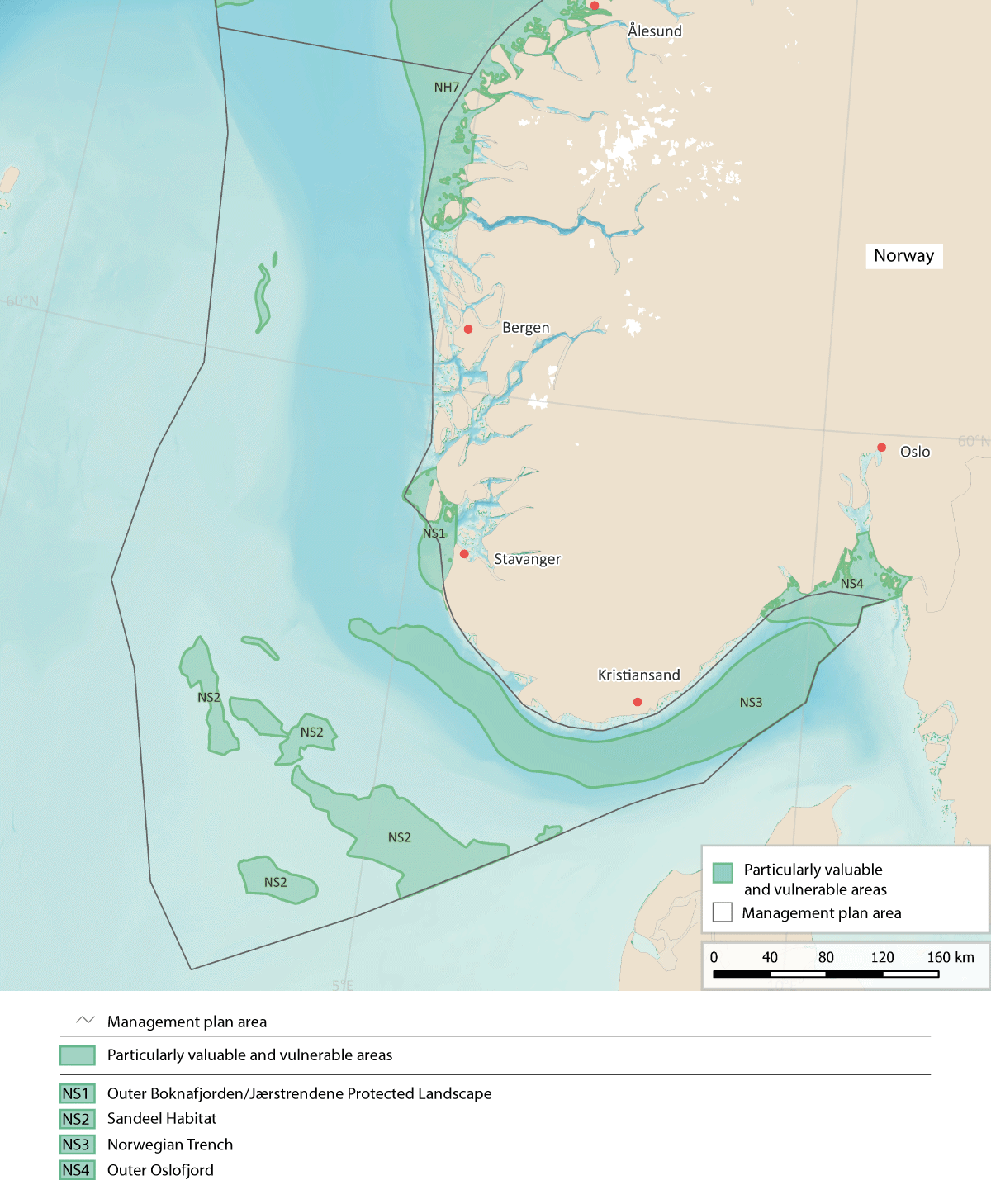
Figure 4.10 Particularly valuable and vulnerable areas in the North Sea and Skagerrak.
Source: Forum for Integrated Ocean Management/Norwegian Environment Agency/Norwegian Mapping Authority/ GEBCO Compilation Group (2023)
Outer Boknafjorden/Jærstrendene Protected Landscape (NS1)
The geological and ecological diversity of this area is high, ranging from open sea out towards the North Sea and the deep Norwegian Trench in the west to shallow kelp forests near the coast. The area is strongly influenced by the Norwegian coastal current flowing out of the Skagerrak, and also largely in contact with the northern part of the North Sea. Water exchange between the Norwegian coastal current and Atlantic water from the deeper layers of the Norwegian Trench results in high zooplankton species diversity and biomass.
The area is important for seabirds and scores high on the EBSA uniqueness criterion. It is an important breeding area for many red-listed species, especially the common tern, and includes the southernmost breeding sites in Norway for kittiwake, common guillemot and puffin. both northerly and southerly species occur here, and it is also an important wintering area, with high species diversity throughout the year. There are relatively large breeding populations of seabirds including common eider, cormorant (subspecies Phalacrocorax carbo sinensis) and shag, and large populations of lesser black-backed gull and herring gull. The Jærkysten MPA, which is part of the area, is in addition an important wintering area for divers, grebes and sea diving ducks from large parts of the Arctic and Fennoscandia.
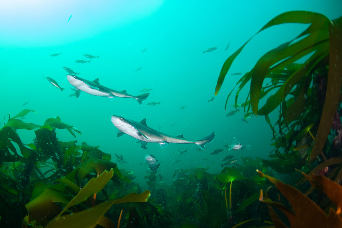
Figure 4.11 Spiny dogfish in the Jærkysten marine protected area.
Photo: Fredrik Myhre, World Wildlife Fund (WWF)
This is also the only area in Norway south of 62 oN where grey seals are known to breed regularly, and is a breeding and moulting area for common seals.
Coastal cod and Norwegian spring-spawning herring are the only fish species for which there is spatial data on spawning areas in the Outer Boknafjorden/Jærstrendene Protected Landscape, but eggs of North Sea cod, haddock, saithe, whiting and flatfish have also been recorded in the area. The sandy seabed in the Jærstrendene area provides particularly good spawning areas for flatfish. Historically, there were also important spawning sites for herring in the area, and these could become important again in the future.
The Karmøyfeltet bank area is important at ecosystem level because of the large concentrations of shrimps, a key species in the ecosystem here. In addition, large aggregations of sponges have been found, and other vulnerable species occur here, such as the bamboo coral Isidella lofotensis, which is considered to be endemic to Norway.
In this area, the vulnerability of eelgrass, the benthic fauna, fish (early life stages of demersal species), seabirds and marine mammals (seals) to various pressures is assessed as high.
Seaweed, kelp and eelgrass show high vulnerability to the extraction of non-living resources (shell sand). The benthic fauna shows high vulnerability to bycatches, selective species extraction, abrasion and habitat loss through sealing of the substrate. Early life stages of fish show high vulnerability to pollution, including oil pollution, and the extraction of non-living resources. Seabirds show high vulnerability to bycatches, disturbance due to human presence, litter, pollution, including oil spills, and alien species (mink). Seals show high vulnerability to bycatches, selective species extraction, and oil pollution.
Seaweed, kelp and eelgrass, benthic fish and most seabirds show high vulnerability to climate change, and negative impacts are expected. The changes may have either positive or negative impacts on the benthic fauna and diving seabirds, depending on the species involved.
Sandeel Habitat (NS2)
Sandeel habitat includes the most important areas of habitat and spawning grounds for sandeels in the Norwegian part of the North Sea.
The seabed in these areas is distinctive, with a substrate of coarse sand and fine gravel at moderate depths, and with good oxygenation conditions. Sandeels have specific habitat requirements, and need specific sediment types that they can burrow into.
Sandeel is the name used for any of several species of the family Ammodytidae, but the lesser sandeel (Ammodytes marinus) is the dominant species in Norwegian waters. In addition to being an important commercial species, the lesser sandeel is a key species in the North Sea ecosystem. Because it has such specific benthic habitat requirements, the species is highly stationary. Sandeels older than about six months spend much of the time buried in the sediment, and when they spawn, the eggs become attached to the sand and gravel. The only period when lesser sandeels are not entirely dependent on suitable bottom conditions is between hatching in February/March and when the larvae settle on the bottom in May/June.
Sandeel Habitat is very important for seabirds, since the lesser sandeel is one of the most important prey species for auks and gulls. The central parts of the North Sea are important for wintering fulmars and to some extent also for kittiwakes. Common guillemots and razorbills also use the area. In addition, Sandeel Habitat is important for feeding grey seals and minke whales.
A decline in the lesser sandeel stock would result in a lack of food for seabirds, fish and marine mammals in the North Sea and along the coastline of Norway and the UK.
Some of the areas designated as Sandeel Habitat are within larger areas where enhanced levels of phytoplankton biomass have been registered. These areas also have higher concentrations of zooplankton than surrounding areas, particularly in spring and summer.
The vulnerability of fish (early life stages and benthic species), seabirds and marine mammals (seals and toothed whales) to various pressures is assessed as high in Sandeel Habitat.
Fish (early life stages and demersal species) show high vulnerability to pollution, including oil pollution, abrasion, and the extraction of non-living resources. Seabirds show high vulnerability to bycatches, litter and pollution, including oil pollution. Seals show high vulnerability to bycatches and selective species extraction, while toothed whales show high vulnerability to pollution.
Seabirds, with the exception of coastal diving species, and benthic fish show high vulnerability to climate change, and the changes are expected to have exclusively negative impacts. The benthic fauna and coastal diving seabird species also show high vulnerability to climate change. However, the changes may have either positive or negative impacts depending on the species.
The Norwegian Trench (NS3)
The area designated as the Norwegian Trench is the section of this deep trench that runs through the Skagerrak parallel to the coast. Because this is a deep-water trench in otherwise shallow waters above the continental shelf, light and temperature conditions, current patterns and other physical conditions are very different from those in surrounding areas. The water is darker, colder and more saline than the shallower waters elsewhere in the North Sea. The Norwegian Trench includes three previously designated areas: Skagerrak, Skagerrak transect (parts) and Listastrendene protected landscape and Siragrunnen.
The species composition of the zooplankton in the Norwegian Trench is quite distinct from that in the rest of the North Sea–Skagerrak, with a large share of mesopelagic species. These include pelagic shrimp species, gelatinous plankton, krill and large copepods, and are not common in the shallow parts of the North Sea. Plankton species from other areas are transported with the inflow of Atlantic water to the deeper water layers. The Norwegian Trench is the only area of the North Sea–Skagerrak that has wintering populations of the copepod Calanus finmarchicus, which is a key species in the pelagic ecosystem. This may be crucial for the distribution of the species along the North Sea–Skagerrak coast, particularly in the spring months when these copepods migrate vertically to surface waters to spawn.
The Norwegian Trench is the only area of the North Sea that offers a natural habitat for deep-water fish. Silvery lightfish is the dominant species. The Skagerrak is an important nursery area for the shrimp Pandalus borealis in the southern part of its range, and may provide a climate refugium for the species in this area as seawater temperatures rise further. Zooplankton, shrimps and various fish species are important in the diet of species that live in the Norwegian Trench, but fish, seabirds and marine mammals living in shallower waters also feed on species that originate from the Trench. The fauna of the Norwegian Trench is part of a separate ecosystem with a unique species composition, and is to a large extent protected from human activity.
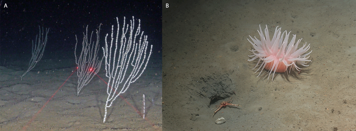
Figure 4.12 Deep-water fauna in the Norwegian Trench. Left: bamboo coral (the red laser dots are 10 cm apart). Right: deeplet sea anemone (Bolocera tuediae).
Photo: From Buhl-Mortensen L, Thangstad TH, Søvik G, Wehde H. 2023. Sea pens and bamboo corals in Skagerrak and the Norwegian trench, Marine Biology Research, Vol 19. https://doi.org/10.1080/17451000.2023.2224967 (left). Mareano/Institute of Marine Research (right).
In this area, the vulnerability of the zooplankton, benthic fauna and seabirds to various pressures is assessed as high. The benthic fauna shows high vulnerability to bycatches, selective species extraction, abrasion and habitat loss through sealing of the substrate. Seabirds show high vulnerability to bycatches, litter, and pollution, including oil pollution. The zooplankton shows high vulnerability to climate change. The benthic fauna also shows generally high vulnerability to climate change, but the impacts may be positive or negative depending on the species involved.
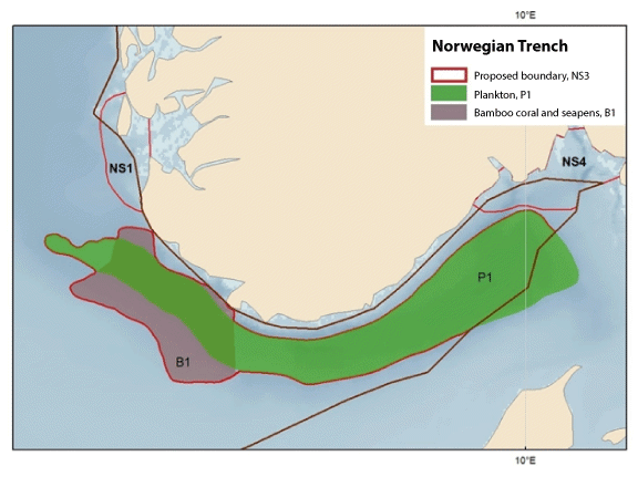
Figure 4.13 Map showing important ecosystem components in the Norwegian Trench. Winter distribution of copepods in the Norwegian Trench (P1) and core areas for bamboo coral (Isidella lofotensis) and several seapen species (B1). The map is based on relative quantities in trawl bycatches from shrimp surveys in the period 2017-2020, and video recordings showing corals and seapens on the seabed. The core areas for seapens coincide with areas where large catches of the shrimp Pandalus borealis were taken.
Source: Institute of Marine Research
There are high densities of vulnerable bamboo coral and seapens in the western section of the deep water in the Skagerrak/Norwegian Trench. Higher densities of bamboo coral stands have been recorded in this area than anywhere else except in fjords. Bamboo coral gardens are listed as an endangered habitat type on Norway’s Red List of ecosystems and habitat types. The seabed in western parts of the Norwegian Trench is being mapped in more detail as part of the MAREANO programme. This includes area B1 (see Figure 4.13), which overlaps with the Norwegian Trench. The results of further surveys and mapping of bamboo coral gardens and seapen communities will provide a basis for evaluating the delimitation of the western part of the Norwegian Trench in the next update of the management plan.
Outer Oslofjord (NS4)
This area is strongly influenced by the Norwegian coastal current, resulting in very distinctive physico-chemical and climatic conditions.
The Outer Oslofjord is an important breeding, passage and wintering area for seabirds, including several threatened species, and meets the EBSA uniqueness criterion. One of the most important breeding areas for the common term (endangered) in Norway is within the designated area. Coastal species such as common eider and red-breasted merganser feed here throughout the year, and the eider populations are of national importance. Herring, great black-backed and common gulls are important species outside the breeding season. The area is also important for little auks in the autumn. The designated area covers part of the wintering distribution of common guillemots from British colonies, and probably also of those from the more southerly colonies in Norway. Considerable numbers of common gulls spend the winter here. Parts of the area are important for common seals all year round, both for breeding and for feeding. The Outer Oslofjord has one of the largest coastal cold-water coral reef complexes in the world. Corals and kelp are habitat-building organisms that are associated with high levels of biodiversity. Kelp detritus that sinks to the bottom is used by shrimps and other crustaceans that live in deep water. Phytoplankton biomass and primary production are higher in the Outer Oslofjord than in the inner Skagerrak and other fjord systems.
In this area, the vulnerability of seaweed, kelp and eelgrass, the benthic fauna, fish, seabirds and marine mammals (seals) to various pressures is assessed as high.
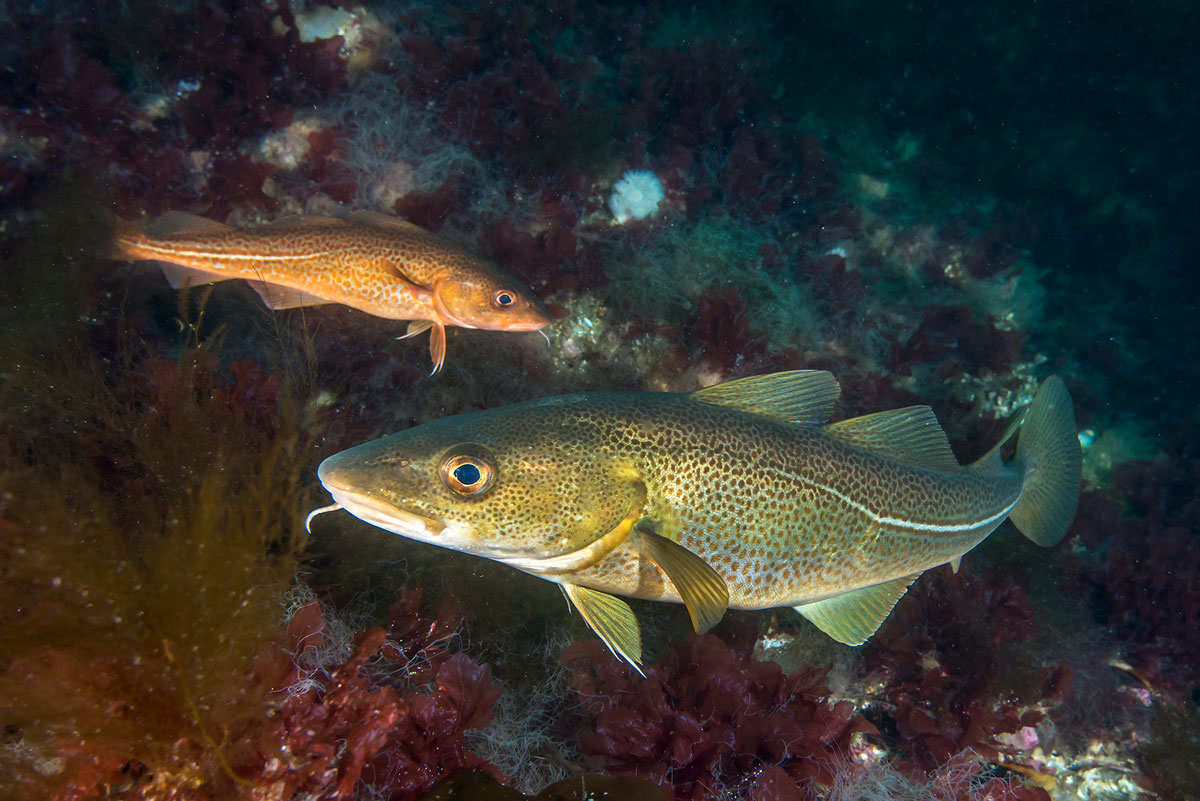
Figure 4.14 Cod in the Skagerrak.
Photo: Erling Svensen
Seaweed, kelp and eelgrass show high vulnerability to pollution and the extraction of non-living resources (shell sand). The benthic fauna shows high vulnerability to bycatches, selective species extraction, abrasion and habitat loss through sealing of the substrate. Fish and shellfish show high vulnerability to species extraction and pollution. Seabirds show high vulnerability to bycatches, selective species extraction, disturbance due to human presence, litter, pollution, oil pollution and alien species (mink). Seals show high vulnerability to selective species extraction and oil pollution.
Seaweed, kelp and eelgrass and seabirds show high vulnerability to climate change. The benthic fauna includes species that show high vulnerability to climate change, but the impacts may be either positive or negative depending on the species involved.
4.2 The conservation of marine biodiversity
Conservation measures, sustainable use and knowledge development are key components of integrated ocean management. Marine ecosystems and their functions relating to biodiversity, production and harvesting from the oceans must be managed in a way that strengthens ecosystem resilience and safeguards biological production in the future.
Efforts to protect valuable biodiversity and marine ecosystem services are based on the new knowledge acquired through mapping, monitoring and research. Knowledge about the marine environment has been developing rapidly in recent years in various areas, including the seabed, seabird populations and oceans and climate change.
The term conservation measures is used to mean both marine protection and other effective area-based conservation measures. Measures and policy instruments are referred to as ‘area-based’ if they apply to geographically delimited areas. Marine protection in Norway refers to the establishment of protected areas under the Nature Diversity Act. These may be either marine protected areas (MPAs), which are a separate category, or for example national parks or nature reserves that include marine areas. Establishing such areas provides long-term protection against environmental pressures and impacts across sectors. The term ‘other effective area-based conservation measures’ (OECMs) was defined by the Conference of the Parties to the Convention on Biological Diversity in a decision in 2018 (CBD/COP/DEC/14/8 Protected areas and other effective area-based conservation measures). Such areas must be geographically defined, their governance and management must achieve positive and sustained outcomes for biodiversity conservation, and management must have the ability to adapt to new threats. Positive and sustained outcomes must be achieved by preventing or significantly reducing threats and by restoring degraded ecosystems. It is also necessary to identify the biodiversity attributes for which an area is important, and as far as possible, such attributes should be documented and monitored.
Marine protected areas and other effective area-based conservation measures are intended to safeguard valuable underwater nature and ecological functions. Rich biodiversity and high biological production, ecosystem services that offer a potential for harvesting, and the value creation that can be achieved by harvesting renewable resources, are all closely interlinked.
Conservation as part of integrated, ecosystem-based ocean management
Conservation measures are used to safeguard areas of importance for biological productivity and diversity, and to maintain ecological functions in areas of special importance for marine biodiversity. Conservation measures also help to enhance ecosystem resilience and improve ecological connectivity where area-based conservation networks are established.
Norway is playing a leading role in developing an integrated, ecosystem-based ocean management regime in order to safeguard biodiversity and ensure sustainable use of ocean resources. Initiatives to promote green solutions and ocean industries will require the availability of large ocean areas for both existing and emerging industries. The High-level Panel for a Sustainable Ocean Economy (Ocean Panel) has published a set of recommendations in which they highlight that achieving a sustainable ocean economy requires effective protection, sustainable production and equitable prosperity to go hand-in-hand. The member countries of the Ocean Panel have undertaken a political commitment to sustainably manage 100 % of the ocean areas under their jurisdiction by 2025. Norway’s system of ocean management, including its ocean management plans and sectoral legislation, has served as a model for these developments. It is in Norway’s interests to maintain and further develop its role as a responsible steward of the oceans.
Climate change and the green transformation are an important part of the backdrop to this update of the ocean management plans. Norway has always had to take large-scale natural fluctuations into account in its ocean management. However, the ocean environment is now undergoing a continuous process of change towards a new and to some degree unknown state, and this is a different and more demanding task than dealing with natural fluctuations.
Conservation of a selection of Norway’s marine areas, habitats and ecosystems is intended both to safeguard valuable biodiversity and ecological functions and to reduce pressures on and the vulnerability of marine ecosystems that are exposed to climate change and ocean acidification.
Conservation measures and climate change
Conservation measures can moderate cumulative impacts on areas of special importance for marine biodiversity, and improve the resilience of the oceans to the impacts of climate change. Thus, conservation measures are a tool for safeguarding marine biodiversity and ecological functions even when conditions in the marine environment are changing.
The nature crisis is affecting life everywhere, including in the oceans. Both the Intergovernmental Panel on Climate Change (IPCC) and the Intergovernmental Science-Policy Platform on Biodiversity and Ecosystem Services (IPBES) have concluded that ocean governance must be adapted to the accelerating pace of climate and environmental change. Ocean governance must take into account the possible impacts of climate change in combination with other drivers of change, and it must be possible to adapt quickly as the situation changes. The IPCC and IPBES have highlighted the importance of developing well designed networks of protected areas to safeguard key marine biodiversity areas. This can help to reduce cumulative impacts on areas and ecosystems that are given special protection, and to protect areas that will become important as the distribution of species and ecosystems changes in response to climate change.
International framework
The Kunming-Montreal Global Biodiversity Framework was adopted at the Conference of the Parties to the Convention on Biological Diversity (CBD COP15) in Montreal in 2022. It applies to all ecosystems, including marine ecosystems. It sets global targets for 2030, including sound planning and management for all areas, restoration of at least 30 % of degraded ecosystems and effective conservation of at least 30 % of terrestrial and marine areas.
In addition to the Global Diversity Framework itself, the conference adopted a separate decision on the conservation and sustainable use of marine and coastal biodiversity. This recognises the importance of marine and coastal biodiversity as one of the key cross-cutting elements of the Global Biodiversity Framework and as critical to achieving the 2050 Vision for biodiversity, in addition, Norway, together with Australia, took the initiative for a statement on the importance of protecting and conserving marine and coastal biodiversity, which was supported by 37 countries. The statement highlights that ‘Recognising the importance of marine and coastal biodiversity, and the connections between coastal and open ocean ecosystems, is one of the key cross-cutting elements of the Post-2020 Global Biodiversity Framework. It is critical we have strong goals and targets on marine and coastal biodiversity, including to protect and conserve at least 30% of the global ocean.’
The conservation of areas of special importance for marine biodiversity
The targets of the Global Biodiversity Framework deal among other things with integrated management, restoration and conservation of ecosystems, including marine ecosystems. The Norwegian Government will present a white paper on a new national biodiversity action plan and describing how the Government will implement the Global Biodiversity Framework.
In 2021, the Storting (Norwegian parliament) formally requested the Government to take action to achieve the target of protecting 10 % of marine and coastal areas by 2030, and to propose a national marine protection plan. The work that is already under way on marine protection will be relevant to this goal. The Government will report back on practical steps to follow up the Storting’s request concerning protection of marine and coastal areas at a later stage.
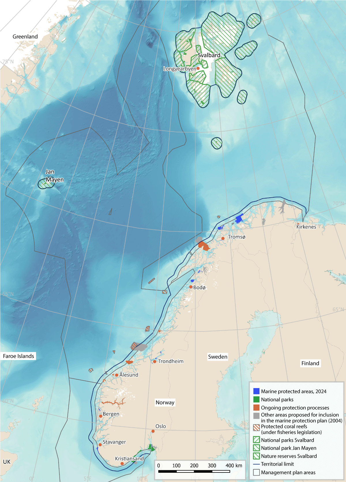
Figure 4.15 Map showing area-based conservation measures (both established and candidate areas) in Norwegian waters.
Source: Norwegian Environment Agency/Marine spatial management tool
Follow-up of the measures set out in the white paper Norway’s integrated plan for the conservation of areas of special importance for marine biodiversity, Meld. St. 29 (2020–2021), will be a key element of further work on the conservation of such areas in Norwegian waters. This work includes the establishment of marine protected areas (MPAs) and identification of other effective area-based conservation measures (OECMs). The Government is continuing work on a draft new act on the conservation of marine biodiversity outside territorial waters and other measures to strengthen conservation efforts, see Chapter 10. The status of work on marine protected areas in territorial waters is further discussed in Chapter 7.2. Areas that need to be shielded from additional pressure caused by human activity – either because they are already under pressure as a result of climate change or ocean acidification, or because they are major carbon sinks – are being identified. This work will continue. The changing ocean climate makes it important to identify areas that are particularly resilient to climate change, known as climate refugia, and to give such areas sufficient priority when establishing MPAs and OECMs.
A proposal has been made to add coral reefs to the list of selected habitat types under the Nature Diversity Act has been made, and a public consultation has been held. The Government’s plan for measures to safeguard threatened species and habitats also includes coral reefs. The other marine habitat types on the list are Radicipes coral gardens, southern sugar kelp forests, eelgrass meadows and mud volcanos. An assessment of the need to protect distinctive and rare species and habitats in deep-sea areas is continuing.
Ecosystem restoration
Restoration of ‘blue forests’ and other valuable habitat types widens the scope of ocean governance to include safeguarding valuable ecological features and enhancing biological production and natural carbon storage. Restoration involves measures to assist the recovery of ecosystems that have been degraded, damaged or destroyed. Conservation measures can contribute to restoration processes. The Global Biodiversity Framework, the UN Decade of Ocean Science for Sustainable Development (2021–2030) and the UN Decade on Ecosystem Restoration (2021–2030) all highlight the importance of both providing access to and disseminating knowledge about the ocean environment, and taking concrete action to improve environmental status and restore ecosystems in marine and coastal areas. Restoration to rebuild ecosystems that have been degraded or destroyed may involve active measures to re-establish habitats, remove sources of pollution, clean up waste, etc. In other cases, passive restoration may be used, which involves limiting use and moderating pressures on the environment, so that ecosystems can recover naturally.
Restoration is an essential tool for halting the loss of biodiversity, limiting greenhouse gas emissions from degraded habitats and dealing with the impacts of climate change. The nature crisis and the climate crisis need to be addressed together, and this is precisely what nature-based solutions such as ecosystem restoration achieve. For example, restoration of ‘blue forests’ – kelp forests, eelgrass meadows, salt marshes and the like – can both maintain major carbon sinks and safeguard biodiversity. Restoration of eelgrass meadows and kelp forests will enhance carbon storage, boost the potential for harvesting and safeguard biodiversity in coastal waters. Marine ecosystems play a key role in efforts to enhance natural carbon capture and storage capacity.
The aim of restoration is to improve the condition of damaged ecosystems, ensure the provision of ecosystem services and make it possible to continue sustainable uses of nature in the future. Reviving ‘blue forests’ can boost carbon storage and also provide a basis for new commercial activities. Action to improve ecosystem condition can both enhance natural biological production and have a positive effect on biodiversity and the potential for harvesting resources.
In the Skagerrak–Oslofjord area, ecosystem condition is being affected by inputs of nutrients and particulate matter from land, and by warmer seawater. The kelp forests have suffered serious decline, much of the natural nursery habitat for gadids and other fish is being lost, and the ecosystem is becoming poorer. Numbers of fish larvae are dropping, and fish stocks are declining. Work on the restoration of marine ecosystems has been started, with a special focus on the Skagerrak–Oslofjord area. The aim is to enhance the productivity and biodiversity of the ecosystems and their capacity for natural carbon capture and storage. A Government initiative is under way to restore good ecosystem condition in the fjord.
‘Blue forests’ – marine and coastal ecosystems such as kelp forests, eelgrass meadows, salt marshes, marine wetlands and in other parts of the world also mangrove forests – have a vital role to play in avoiding and resolving challenges related to the climate and nature crises. Blue forests are nature’s own way of moderating climate change and supporting high levels of biodiversity. Intact blue forests provide ecosystem services such as carbon sequestration and healthy fish stocks. They support rich biodiversity and are important habitats and nursery areas for a wide range of species. In addition, carbon uptake and storage in these ecosystems means that they play a part in mitigating climate change. The Ocean Panel highlights the importance of blue carbon ecosystems in providing solutions to challenges related to carbon storage, acidification, warming and the loss of biodiversity in the oceans. The restoration of degraded ocean ecosystems can prevent the loss of habitats of special importance for marine biodiversity and carbon storage, such as blue forests.
4.3 Management of coastal water bodies
Various authorities at national, regional and municipal level are involved in the management of Norway’s coastal waters. They are responsible for different activities and interests, for example the fisheries, aquaculture, shipping, spatial planning, pollution and the environment. These authorities operate at different but overlapping geographical scales.
The EU Water Framework Directive has been implemented in Norwegian law through the Water Management Regulations. This is a permanent ecosystem-based management regime. The purpose of the regulations is to provide a framework for establishing environmental objectives to ensure an integrated approach to the protection and sustainable use of water bodies. For coastal waters, the geographical scope of the regulations is from land or the outer limit of transitional (brackish) waters to one nautical mile outside the baseline, and out to the outer limit of territorial waters in respect of chemical status. The general objectives of the Water Management Regulations are to achieve good ecological status and good chemical status. Coastal waters are divided into water bodies, and the management plans drawn up under the regulations specify the environmental objectives for each water body. Norway’s coastal waters are divided into 2284 water bodies. In 2023, almost 75 % of these were classified as having good or high ecological status according to the system used in the Water Management Regulations.
The status of water bodies is assessed according to the classification system set out in the Water Management Regulations. The overall status of each water body is determined using chemical, physical and biological parameters. The regulations specify biological quality elements for each category of water body (rivers, lakes, coastal water and groundwater).
The ecological status of coastal water bodies is defined on the basis of assessments of four selected biological quality elements as set out in the regulations: phytoplankton, macroalgae, eelgrass and soft-bottom benthic invertebrates. These quality elements were primarily developed to give an indication of pressure from eutrophication and to some extent from organic matter, sedimentation, chemical pollution and physical disturbance that changes tidal and hydromorphological conditions. However, these four biological quality elements are not particularly suitable for providing information on the ecological status of coastal waters with respect to biodiversity. For example, fish are not currently included as a biological quality element for coastal waters either in the Water Framework Directive or in the Water Management Regulations. In many other European countries, large areas along the coastline are defined as transitional waters, and the fish fauna is included as a biological quality element for these water bodies in the directive. However, there are few areas of this kind in Norway. This means that the criteria currently used in the Water Management Regulations do not give a complete picture of the status of coastal waters. For example, under the Water Framework Directive, ecological status is found to be good in some parts of the Oslofjord and moderate in other parts. This is despite the fact that we know, to give one example, that stocks of cod and other gadids have collapsed and are at historically low levels.
It is possible for Norway to include extra quality elements in the Water Management Regulations, in addition to those specified in the Water Framework Directive. Quality elements in the regulations should be designed to provide a satisfactory assessment of pressures that are of significance for ecosystems in coastal waters. These ecosystems also have ecological links with adjoining marine areas. To provide a better knowledge base and a more complete picture of the ecological status of coastal waters under the Water Management Regulations, the Government will consider whether more ecosystem components should be included in the assessments.
4.4 Nature-based solutions
Nature-based solutions are solutions inspired or supported by nature to address major environmental, social and economic challenges in sustainable ways. Examples include action to maintain or restore nature or the climate benefits of nature, and action that uses nature to enhance the uptake of greenhouse gases. In the past ten years, there has been growing awareness across sectors of the role nature-based solutions can play in addressing climate change.
In 2022, the UN Environment Assembly agreed on a definition of the term ‘nature-based solutions’, which has been adopted by both the Climate Change Convention and the Convention on Biological Diversity. This makes it clear that nature-based solutions must provide biodiversity benefits, and reads as follows: ‘… nature-based solutions are actions to protect, conserve, restore, sustainably use and manage natural or modified terrestrial, freshwater, coastal and marine ecosystems which address social, economic and environmental challenges effectively and adaptively, while simultaneously providing human well-being, ecosystem services, resilience and biodiversity benefits.’
4.4.1 Blue forests and carbon sequestration in sediments
‘Blue forests’ is a generic term for marine and coastal ecosystems that capture and store carbon, support rich biodiversity and form habitats for many different organisms, and so can be likened to terrestrial forests. Kelp forests make up the largest ecosystem by area in both Norway and the world as a whole. Kelp forests, together with seaweed communities, eelgrass meadows and salt marshes, are Norway’s blue forests. They form vital habitats for biodiversity in both coastal and marine waters. In addition, blue forests can play an important role in the green transition.
Interest in and understanding of the oceanic carbon cycle has been growing in recent years, and there has been a particular focus on the importance of organic carbon stored in marine vegetation or sequestered in the seabed. The marine ecosystems that are most important for carbon storage in Norwegian waters are macroalgae (kelp and seaweed), eelgrass meadows, salt marshes, and sediments and the soft-bottom fauna.
A large proportion of European kelp forests are in Norwegian waters. Healthy kelp forests sequester large quantities of carbon dioxide (CO2), while at the same time producing oxygen (O2), which is vital for life in the sea. Kelp can also remove inorganic nitrogen (N) and phosphorus (P) from coastal waters. These nutrients are currently a growing problem for water quality in many densely populated coastal areas. Macroalgae (kelp and seaweeds) make the largest contribution to carbon uptake and storage in Norway’s coastal waters.
Macroalgae grow in all coastal counties from Agder in the south to Troms and Finnmark in the north, and also around Svalbard, and cover around 10 000 km2 of the seabed along the coast of mainland Norway. Two kelp species, Laminaria hyperborea and Saccharina latissima (sugar kelp), and seaweeds make up about one third of this area each. Eelgrass meadows cover an area of only about 90 km2. Salt marshes have not been mapped sufficiently to estimate the total area in Norway. Soft-bottom habitats on the seabed are the most widespread of the marine habitats that are important for carbon storage in Norway, covering a total of more than 77 000 km2 in coastal waters (less than 12 nautical miles from the baseline).
It is estimated that in the territorial waters around mainland Norway, these ecosystem types account for annual uptake and storage of about 5 million tonnes CO2eq. This is equivalent to about 10 % of Norway’s emissions and 1/3 of annual uptake and storage on land. We lack updated figures for the remaining ocean areas under Norwegian jurisdiction.
Blue carbon, i.e. carbon captured by living organisms in coastal ecosystems (macroalgae, eelgrass meadows, salt marshes, and sediments and the benthic fauna) and stored in biomass and sediments, has become a focus of international policy in recent years. The growing interest in blue carbon is linked to recognition of the important opportunities that restoration and conservation of these ecosystems may provide for achieving several of the sustainable development goals – this may be through adaptation to climate change, greater protection against storms and coastal erosion, food supplies from the oceans, improvements in living conditions, employment opportunities, protection of biodiversity or better water quality.
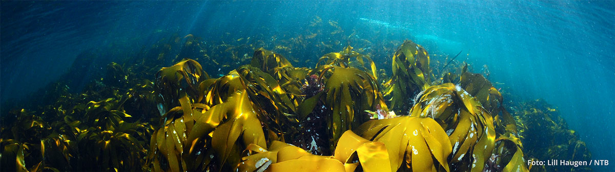
Figure 4.16 Blue forest. A kelp forest off the island of Runde.
Photo: © Lill Haugen, NTB
At global level, kelp and seaweed cultivation is the most rapidly growing aquaculture industry, with an annual growth rate of 6.2 % over the past 20 years. Seaweed output is highest in Asia, but commercial cultivation has now started in Norway as well. Industrial extraction of alginate has also started, based on kelp harvesting along the coast. Efforts are under way to develop new industrial opportunities based on kelp, such as renewable feed supplies for fish farming, replacements for plastics, and biofuel.
Healthy kelp forests are also important for sustainable fisheries, aquaculture and tourism because they support healthy, productive ecosystems and provide ecosystem services. In Norway, coastal communities have a long history of using kelp forests as an importance resource, both as a nutritious supplement to other livestock feed and for soil improvement. The conservation of kelp forests can also reduce carbon loss and emissions and safeguard a variety of other ecosystem services. Similarly, the restoration of kelp forests will boost carbon fixation, re-establish habitats and improve resilience to extreme weather events. Thus, healthy blue forests improve the health and resilience of a range of ecosystems.
Short-term carbon storage
Marine vegetation functions as a short-term carbon store through carbon uptake from the seawater and storage in biomass. The short-term carbon pool in kelp forests along the coast of mainland Norway is estimated at almost 5 million tonnes carbon, or 18 million tonnes CO2eq. This corresponds to about 1 % of the standing stock of carbon in trees in Norwegian forests. The carbon pool in seaweed communities is estimated at 0.9 million tonnes carbon (about 3.2 million tonnes CO2eq), while eelgrass meadows store 252 000 tonnes carbon (about 0.9 million tonnes CO2eq). In eelgrass meadows, most of the short-term carbon pool is in the form of dead organic material in the sediments below the vegetation.
In total, it is estimated that the carbon pool in seaweed, kelp and eelgrass ecosystems is about 22.1 million tonnes CO2eq in the vegetation itself and in the sediments directly below the vegetation.
Long-term carbon storage (sequestration)
The seabed is the final destination for carbon that is captured by marine habitats, and makes up the largest marine carbon store. Long-term storage of carbon takes place in the sediments. Carbon sequestered in the seabed may also originate from land. It is estimated that there is a carbon pool of about 137 million tonnes in the upper 25 cm of the seabed sediments in soft-bottom areas in Norway’s coastal waters (less than 12 nautical miles from the baseline), an area of about 77 000 km2. If the upper metre or several metres of the sediments is included, the estimated figure for the carbon pool increases more or less proportionally.
Soft-bottom areas of seabed and kelp forests cover large areas and are carbon stores of national importance. Eelgrass meadows and salt marshes cover considerably smaller areas, but store more carbon per unit area than for example kelp forests.
Estimates of annual sequestration rates for the different ecosystem types in coastal waters show that kelp forests store the largest quantity of carbon per year, about 0.5 million tonnes (1.8 million tonnes CO2eq), followed by seaweed communities (0.43 million tonnes CO2eq per year) and eelgrass meadows (0.017 million tonnes CO2eq per year). In total, these ecosystems sequester roughly 2.2 million tonnes CO2eq per year, corresponding to 4.5 % of Norway’s total CO2 emissions. These figures provide an estimate of how much CO2 is removed from the atmosphere each year by the blue forests in Norway’s coastal waters.
4.5 Ocean accounting
The Ocean Panel brings together 18 countries that have undertaken a political commitment to sustainably manage 100 % of the ocean area under their jurisdiction by 2025 on the basis of sustainable ocean plans. The Ocean Panel has adopted a framework with various outcomes to be achieved by 2030. One of these is that ‘decision-making affecting the ocean reflects the value of and impacts on the ocean’s natural capital.’ The Panel identifies the development of national ocean accounts as one way of achieving this outcome. The Forum for Integrated Ocean Management has considered how the development of ocean accounting can be followed up in Norway, and in particular how ocean accounting can be used in further work on the elements of the ocean management plans relating to value creation and ecosystem services.
A pilot version of an ocean satellite account for Norway has already been published (consistent with the System of National Accounts, SNA), while the development of a system of ecosystem accounting (based on the SEEA EA) and complete thematic ocean accounts will take longer.
Textbox 4.1 Main components of an ocean accounting system
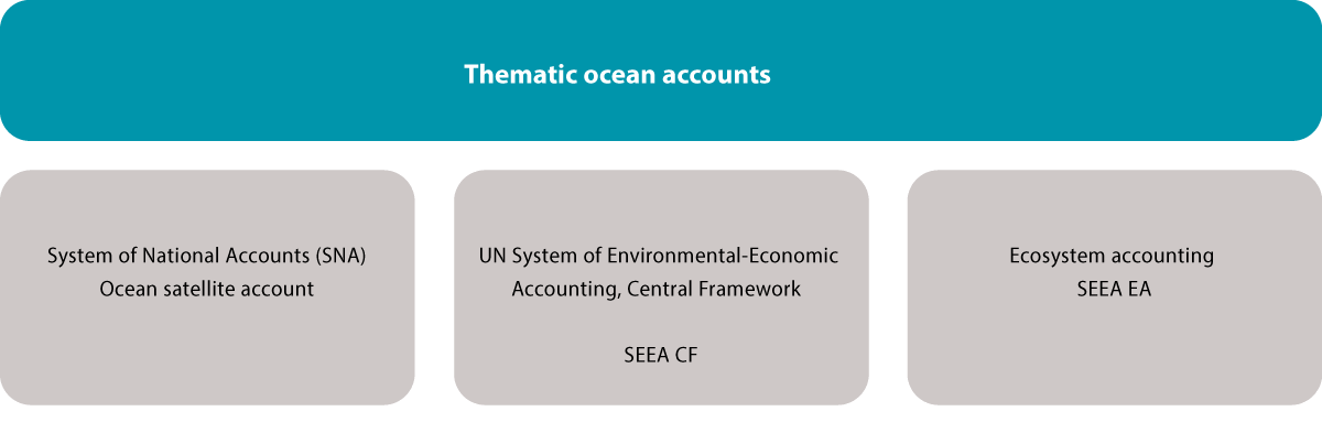
Figure 4.17 Main components of an ocean accounting system
Source: Norwegian Environment Agency
Thematic ocean accounts combine information on economic, environmental and social topics relating to marine and coastal waters using a country’s national accounts and the UN System of Environmental-Economic Accounting (SEEA). Three internationally agreed accounting frameworks are used: the System of National Accounts (SNA), the SEEA Central Framework and SEEA Ecosystem Accounting. The SEEA Central Framework is based on the same principles as the SNA, so that accounts based on them are complementary and compatible with each other.
Ocean-related economic activity is extracted from the national accounts in an ocean satellite account. This provides an overview of economic activity at national level in a particular year in industries and sectors that are directly or indirectly ocean-related. For example, it could provide information on the proportion of value creation from the fisheries industry in the course of a year. The satellite account will not provide any information on whether or not this value creation is sustainable.
The SEEA Central Framework (SEEA CF) provides information on links between the economy and the environment. Information on direct anthropogenic drivers and the use of natural resources is recorded here, for example emission and energy accounts. The SSEA CF provides information on how human/economic activity affects the natural environment.
The SEEA Ecosystem Account (SEEA EA) system is based on spatially explicit (map-based) information and consists of five core accounts: ecosystem extent, ecosystem condition, two ecosystem services accounts (biophysical and monetary) and a monetary ecosystem asset account. The system is designed to be developed from the bottom upwards, using spatial data on ecosystem extent as a basis. The ecosystem extent account provides systematic information on the area of different ecosystem types. The ecosystem condition account records the condition of the same ecosystems relative to a reference state. The biophysical ecosystem services account provides information on the flows of ecosystem service provided by ecosystems and who uses them. The monetary ecosystem services account is based on the previous account and uses monetary values for transactions in order to estimate the monetary value of some ecosystem services. Provided that the other four accounts exist, it is possible to estimate the monetary value of ecosystem assets (also known as natural capital) for each year.
Most work on establishing environmental economic accounting has focused on terrestrial ecosystems and freshwater resources. Further development of the accounting framework is therefore needed to take into account issues of particular relevance to marine ecosystems, such as their three-dimensional nature (water column and volume), migratory species and determining the reference condition of ecosystems. In addition, the concept of incorporating information from the three different accounting frameworks into a thematic ocean account is relatively new. The UN has therefore initiated work on the development of SEEA Ocean, which will consider how to develop the three accounting frameworks and use them together to develop a thematic ocean account.
The results from Norway’s ocean satellite account have been used to describe value creation in the ocean industries. A project to develop a pilot marine ecosystem account for the area Coastal Zone Lofoten has also been started, focusing mainly on the three physical accounts – ecosystem extent, ecosystem condition and a biophysical ecosystem services account. The purpose of this project is to build up expertise on ocean accounting in the public administration, test the use of the accounting frameworks in practice and provide input to international development work.
4.6 Ecosystem services
Norwegian society derives major benefits from the ecosystems in Norwegian waters, which for example contribute to food supplies, regulating services and opportunities for recreation. Well-functioning ecosystems that provide ecosystem services are essential to ensure that Norway’s ocean areas continue to contribute to Norway’s welfare in the future.
In contrast to economic value creation, which is reported in the national accounts, no system has been established for collecting data on ecosystem services in Norway. The Norwegian Environment Agency and Statistics Norway, in cooperation with the Forum for Integrated Ocean Management, are now working on the development of ecosystem accounting for Norwegian ocean areas. The particularly valuable and vulnerable area Coastal Zone Lofoten has been chosen as a pilot, since a great deal of data and knowledge is available about the ecosystems and ecosystem components in this area. This makes it possible to test the extent to which ecosystem services can be described using the current knowledge base. The work will also provide a basis for evaluating whether the results can be used to describe changes and trends, and whether the methodology is transferable to other ocean areas.
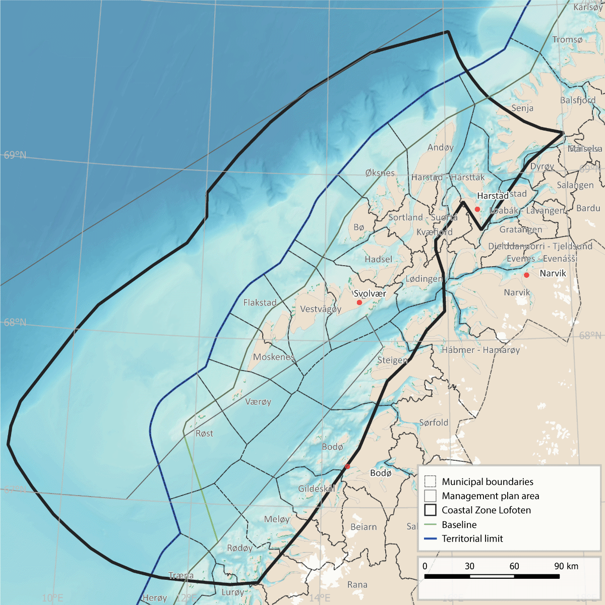
Figure 4.18 Map of the pilot area for ecosystem services, Coastal Zone Lofoten, showing municipalities within and adjacent to the area.
Source: Norwegian Environment Agency
Biological resources can move or be transported for considerable distances, and within the Coastal Zone Lofoten many ecosystem services are dependent on processes that take place outside the area. Moreover, processes in the marine environment can have implications for recreation and tourism on land or closer to the coast, and processes on land can influence marine ecosystems. Many of the ecosystem components that are typical of the area are only found there for parts of the year. A report has been published describing marine ecosystem components and ecosystem services within the boundary of the Coastal Zone Lofoten.
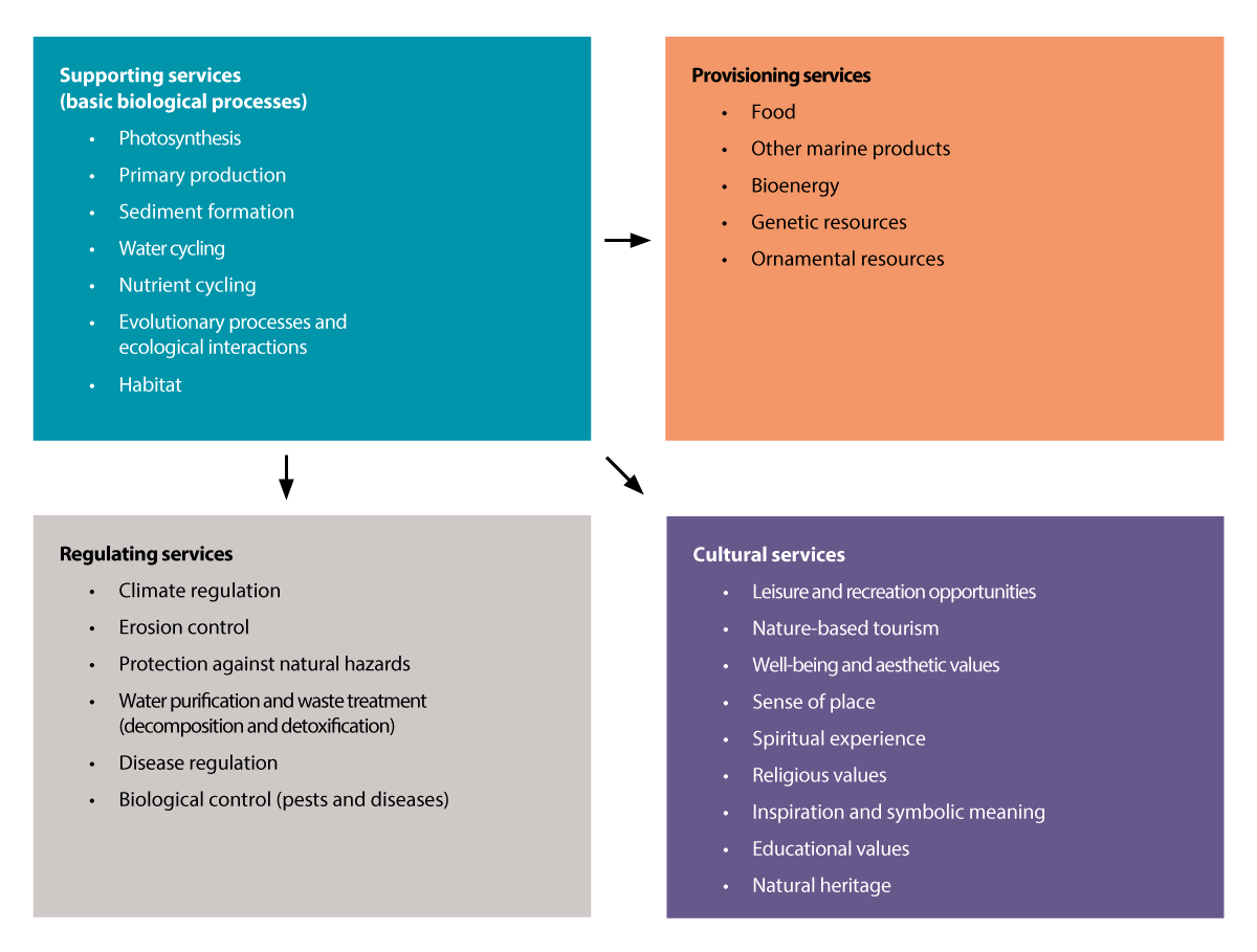
Figure 4.19 The four categories of ecosystem services, with examples that are relevant to marine and coastal waters.
Sources: Adapted from NOU 2013: 10.
More knowledge is needed both about the ecological structures and functions that underpin ecosystem services and about flows of ecosystem services to make it possible to describe changes and trends. Knowledge about changes in ecosystems and the structures and functions underlying ecosystem services is needed to identify whether current patterns of use are sustainable and reveal what future changes are to be expected in flows of ecosystem services. Similarly, information about changes in flows of ecosystem services is important for an understanding of how society is using ecosystems and ecosystem components. In the pilot project, the ecosystem components present in the area have been used as a basis for describing the ecosystems, and thus the structures and functions underlying ecosystem services. The descriptions of these components are largely based on earlier work on the scientific basis for the management plans, using the following ecosystem components: benthic communities, phytoplankton, zooplankton, fish, seabirds and marine mammals.
The ocean currents and topography in the Coastal Zone Lofoten result in upwelling of nutrient-rich deep water to the upper water layers, creating highly favourable conditions for biological production. As a result, primary production by phytoplankton, seaweed and kelp is continuously high. Because the continental shelf is narrow in this area, there are strong currents, concentrating passively transported organisms (zooplankton and fish eggs and larvae). The high level of production and large concentrations of organisms that are important as food for other animals in the food web mean that this is a very important area for seabirds, whales, various benthic species, and commercially important fish species such as cod, saithe, haddock and herring.
4.7 Knowledge building and knowledge needs
A sound knowledge of ecosystems, ecosystem condition and ocean-related activities is the foundation for integrated ocean management. Information on areas of importance for ecosystem functioning and nature-based solutions is crucial for sustainable ocean management. Norway is therefore focusing closely on the management of the designated particularly valuable and vulnerable areas.
Growing problems related to the oceans and climate change, including biodiversity loss, ocean acidification, pollution, plastic waste and other drivers, are affecting the dynamics and functioning of ecosystems, and action must be taken to ensure that marine ecosystems are resilient and productive. We need more knowledge and a better understanding of ecosystem functioning and ecological relationships, and about the cumulative impacts of climate change and other drivers. Work is being done to improve our knowledge of species, habitats and marine ecosystems and their vulnerability, for example for seamounts and active vent fields in deep-sea areas.
Research cooperation and the establishment of pilot projects on the restoration of marine ecosystems is an important element of Nordic cooperation. Experience gained from work in the Baltic Sea can be used in strengthening cooperation on environment and sustainability in the Skagerrak region. Norway is also working on a national pilot project to improve ecosystem condition in the Skagerrak, focusing on the national parks in the Skagerrak-Oslofjord area. One aim is to build up knowledge of the effects of restoration measures.
Seabed ecosystems and habitat types
Seabed mapping provides important information on areas of crucial importance for marine ecosystem functioning. The MAREANO programme is mapping the seabed in Norwegian waters and thus strengthening the knowledge base. Seabed mapping is also an important basis for integrated, ecosystem-based management. It is important to continue this work to build up knowledge about seabed habitat types and biotopes with important functions, and about the resilience and vulnerability of marine benthic ecosystems to different pressures and to cumulative impacts, based partly on data from the MAREANO programme.
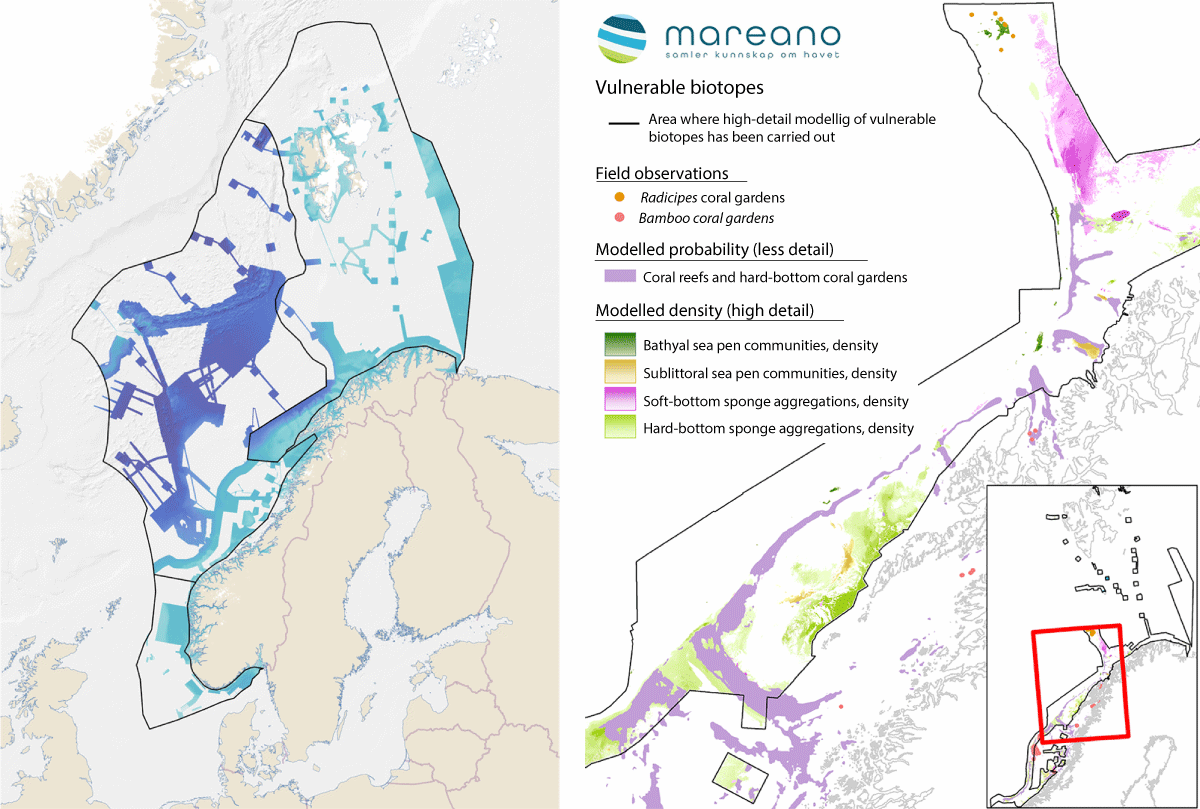
Figure 4.20 Mapping the seabed. Areas where the MAREANO programme has mapped depth and topography or obtained data from other sources (left). Vulnerable habitats modelled on the basis of data collected by the MAREANO programme (right).
Source: Mareano
Seabird populations, distribution and migration
Systematic mapping and monitoring is generating a considerable amount of new information about seabird population trends, and more understanding of changes in ecosystems, and information about migratory patterns and seabird habitat use throughout the year. Knowledge about seabird populations is being built up through the SEAPOP programme and the SEATRACK tracking module. Since 2014, the winter distribution of Norwegian seabirds has been mapped using light loggers, or GLS loggers. This has given a completely new understanding of seabird migration patterns and wintering areas. The results so far show that the ice-free parts of the Barents Sea and waters north of Iceland are very important wintering areas (November–January) for adult birds of the six most abundant Norwegian pelagic seabirds (fulmar, kittiwake, common guillemot, Brünnich’s guillemot, puffin and little auk). The entire Norwegian population of common guillemot winters in the Barents Sea. Brünnich’s guillemots follow a mixed strategy. Birds from mainland Norway and the eastern parts of Svalbard winter in the Barents Sea, while those that breed on Bjørnøya and along the west coast of Spitsbergen winter around Iceland and south of Greenland. For kittiwakes, puffins and little auks, other important wintering areas are north of Iceland and south and west of the southern tip of Greenland (the Labrador Sea). Fulmars from Norwegian colonies spread across large areas of the Northeast Atlantic during the winter. Tracking data and knowledge generated through SEAPOP and SEATRACK is providing a very important scientific basis for ocean management both in Norway and internationally at a time when ecosystems are changing rapidly and an integrated approach is crucial.
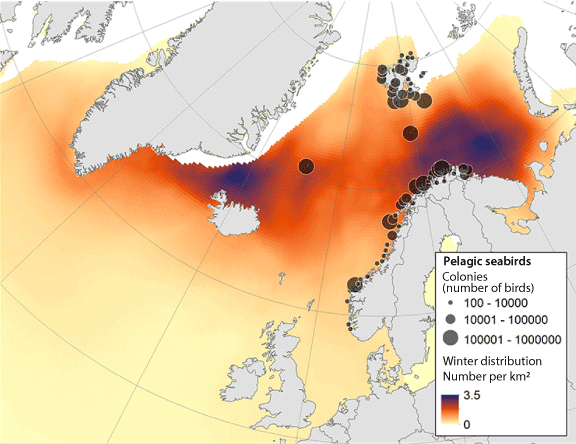
Figure 4.21 Colonies and winter distribution (November-January) of the six most abundant pelagic seabirds that breed in Norway (fulmar, kittiwake, common guillemot, Brünnich's guillemot, puffin and little auk).
Source: SEATRACK and SEAPOP.